Aleg geodata
Aleg (Brakna) is a seat of a first-order administrative division; located in Mauritania in Africa/Nouakchott (GMT+0) time zone. With population of 15,211 people, there are 10 cities with bigger population in this country. Compared to other cities in Mauritania, 52.6% of cities are located further ↑North; 52.6% of cities are located further →East and 57.9% of cities have higher elevation than Aleg. Note1


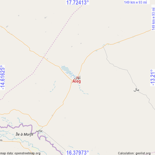
Aleg GPS coordinates[2]
17° 3' 11.304" North, 13° 54' 47.232" West
| Map corner | latitude | longitude |
|---|---|---|
| Upper-left | 17.72413°, | -14.61625° |
| Center: | 17.05314°, | -13.91312° |
| Lower-right: | 16.37973°, | -13.21° |
| Map W x H: | 149.5×149.5 km | = 92.9×92.9mi |
| max Lat: | 22.73542° ⇑52.6% North |
| Aleg: | 17.05314° |
| min Lat: | ⇓47.4% South 15.15846° |
| min Long | Aleg | max Long |
| -17.03842° | -13.91312° | -7.25649° |
| W 47.4%⇐ | ⇒52.6% E |
Elevation
Elevation of Aleg is 40 m = 131 ft, and this is 86.1 m = 282 ft below average elevation for this country.
| Max E: |
500 m = 1640 ft | 57.9% |
| Avg. | 126.1 m = 414 ft | |
| Aleg | 40 m = 131 ft | |
Min E: |
1 m = 3 ft | 42.1% |
See also: Mauritania elevation on elevation.city.
Geographical zone
Aleg is located in North Torrid zone (between Equator and Tropic of Cancer). Distance of this Northern Tropic circle is 709.8 km =441 mi to North.| Distance of | km | miles | from Aleg |
|---|---|---|---|
| North Pole | 8110.9 | 5039.9 | to North |
| Arctic Circle | 5505 | 3420.6 | to North |
| Tropic Cancer | 709.8 | 441 | to North |
| Equator | 1896.1 | 1178.2 | to South |


Nearby cities:
15 places around Aleg: (largest is in red/bold)
• Akjoujt
303.6 km =188.6 mi,  350°
350°
• Arafat
244.6 km =152 mi,  296°
296°
• Atar
395.8 km =245.9 mi,  13°
13°
• Barkéwol
157.4 km =97.8 mi,  106°
106°
• Chingueṭṭi
412.8 km =256.5 mi,  23°
23°
• Dar Naim
243.5 km =151.3 mi, 298°
• Kaédi
109.5 km =68 mi,  156°
156°
• Kiffa
271.5 km =168.7 mi,  100°
100°
• Nouakchott
247.2 km =153.6 mi, 297°
• Rosso
210.1 km =130.6 mi,  253°
253°
• Sélibaby
280.2 km =174.1 mi,  138°
138°
• Tevragh Zeina
248.8 km =154.6 mi, 297°
• Tidjikja
311.8 km =193.7 mi,  57°
57°
• Tékane
160.8 km =99.9 mi, 251°
• ’Elb el Jmel
7.8 km =4.8 mi,  232°
232°
Sources, notices
• [Note1] Compared only with cities in Mauritania existing in our database
• [Src1] Map data: © OpenStreetMap contributors (CC-BY-SA)
• [Src2] Other city data from geonames.org with taken over terms of usage.
• [Src3] Geographical zone / Annual Mean Temperature by Robert A. Rohde @ Wikipedia
