Valletta geodata
Valletta (Il-Belt Valletta) is a capital of a political entity; located in Malta in Europe/Malta (GMT+2) time zone. With population of 6,794 people, there are 23 cities with bigger population in this country. Compared to other cities in Malta, 53.5% of cities are located further ↓South; 83.1% of cities are located further ←West and 70.4% of cities have higher elevation than Valletta. Note1


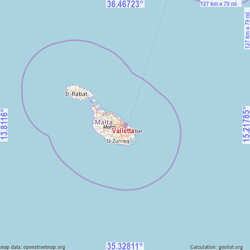
Valletta GPS coordinates[2]
35° 53' 58.992" North, 14° 30' 52.992" East
| Map corner | latitude | longitude |
|---|---|---|
| Upper-left | 36.46723°, | 13.8116° |
| Center: | 35.89972°, | 14.51472° |
| Lower-right: | 35.32811°, | 15.21785° |
| Map W x H: | 126.7×126.7 km | = 78.7×78.7mi |
| max Lat: | 36.07222° ⇑46.5% North |
| Valletta: | 35.89972° |
| min Lat: | ⇓53.5% South 35.82583° |
| min Long | Valletta | max Long |
| 14.20361° | 14.51472° | 14.56701° |
| W 83.1%⇐ | ⇒16.9% E |
Elevation
Elevation of Valletta is 44 m = 144 ft, and this is 34.1 m = 112 ft below average elevation for this country.
| Max E: |
231 m = 758 ft | 70.4% |
| Avg. | 78.1 m = 256 ft | |
| Valletta | 44 m = 144 ft | |
Min E: |
5 m = 16 ft | 29.6% |
See also: Malta elevation on elevation.city.
Geographical zone
Valletta is located in North temperate zone (between Tropic of Cancer and the Arctic Circle). Distance of this Northern Tropic circle is 1385.8 km =861.1 mi to South.| Distance of | km | miles | from Valletta |
|---|---|---|---|
| North Pole | 6015.4 | 3737.8 | to North |
| Arctic Circle | 3409.5 | 2118.6 | to North |
| Tropic Cancer | 1385.8 | 861.1 | to South |
| Equator | 3991.7 | 2480.3 | to South |


Nearby cities:
15 places around Valletta: (largest is in red/bold)
• Cospicua
2 km =1.2 mi,  143°
143°
• Floriana
0.7 km =0.4 mi,  233°
233°
• Gżira
2.5 km =1.6 mi,  285°
285°
• Imsida
3 km =1.9 mi,  254°
254°
• Kalkara
2 km =1.2 mi,  125°
125°
• Marsa
2.9 km =1.8 mi,  217°
217°
• Pietà
1.9 km =1.2 mi, 252°
• San Ġiljan
3.1 km =1.9 mi,  312°
312°
• Senglea
1.4 km =0.9 mi,  171°
171°
• Sliema
1.8 km =1.1 mi,  320°
320°
• Ta’ Xbiex
1.8 km =1.1 mi,  268°
268°
• Vittoriosa
0.9 km =0.6 mi,  158°
158°
• Xgħajra
3.3 km =2.1 mi,  118°
118°
• Ħamrun
3.2 km =2 mi,  238°
238°
• Żabbar
3.2 km =2 mi,  145°
145°
In other languages:
- In Spanish: Valletta, La Valeta
- In France: La Valette
- In Italian: La Valletta
- In Russian: Валлетта
- In Chinese: 瓦莱塔
Sources, notices
• [Note1] Compared only with cities in Malta existing in our database
• [Src1] Map data: © OpenStreetMap contributors (CC-BY-SA)
• [Src2] Other city data from geonames.org with taken over terms of usage.
• [Src3] Geographical zone / Annual Mean Temperature by Robert A. Rohde @ Wikipedia
