Clémencia geodata
Clémencia (Flacq) is a populated place; located in Mauritius in Indian/Mauritius (GMT+4) time zone. With population of 1,835 people, there are 89 cities with bigger population in this country. Compared to other cities in Mauritius, 63.6% of cities are located further ↑North; 81.8% of cities are located further ←West and 50.5% of cities have higher elevation than Clémencia. Note1


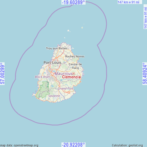
Clémencia GPS coordinates[2]
20° 15' 50.004" South, 57° 42' 21.996" East
| Map corner | latitude | longitude |
|---|---|---|
| Upper-left | -19.60289°, | 57.00299° |
| Center: | -20.26389°, | 57.70611° |
| Lower-right: | -20.92208°, | 58.40924° |
| Map W x H: | 146.7×146.7 km | = 91.2×91.2mi |
| max Lat: | -10.38803° ⇑63.6% North |
| Clémencia: | -20.26389° |
| min Lat: | ⇓36.4% South -20.51667° |
| min Long | Clémencia | max Long |
| 56.61795° | 57.70611° | 63.41667° |
| W 81.8%⇐ | ⇒18.2% E |
Elevation
Elevation of Clémencia is 108 m = 354 ft, and this is 44.1 m = 145 ft below average elevation for this country.
| Max E: |
467 m = 1532 ft | 50.5% |
| Avg. | 152.1 m = 499 ft | |
| Clémencia | 108 m = 354 ft | |
Min E: |
1 m = 3 ft | 49.5% |
See also: Mauritius elevation on elevation.city.
Geographical zone
Clémencia is located in South Torrid zone (between Equator and Tropic of Capricorn). Distance of this Southern Tropic circle is 352.8 km =219.2 mi to South.| Distance of | km | miles | from Clémencia |
|---|---|---|---|
| Equator | 2253.1 | 1400 | to North |
| Tropic Capricorn | 352.8 | 219.2 | to South |
| Antarctic Circle | 5148 | 3198.8 | to South |
| South Pole | 7753.9 | 4818 | to South |


Nearby cities:
15 places around Clémencia: (largest is in red/bold)
• Bel Air Rivière Sèche
4.6 km =2.9 mi,  81°
81°
• Camp Ithier
6.7 km =4.2 mi,  37°
37°
• Camp de Masque
5.4 km =3.4 mi,  303°
303°
• Centre de Flacq
8.3 km =5.2 mi,  6°
6°
• Ecroignard
5.2 km =3.2 mi, 36°
• Grand Sable
8.3 km =5.2 mi,  132°
132°
• Grande Rivière Sud Est
7.7 km =4.8 mi,  108°
108°
• Mare La Chaux
8.6 km =5.3 mi,  31°
31°
• Melrose
7.8 km =4.8 mi,  265°
265°
• Montagne Blanche
5.5 km =3.4 mi,  244°
244°
• Olivia
3.7 km =2.3 mi,  135°
135°
• Quatre Soeurs
7.8 km =4.8 mi,  120°
120°
• Queen Victoria
4.9 km =3 mi,  1°
1°
• Saint Julien
8.4 km =5.2 mi, 299°
• Sebastopol
3.5 km =2.2 mi,  212°
212°
Sources, notices
• [Note1] Compared only with cities in Mauritius existing in our database
• [Src1] Map data: © OpenStreetMap contributors (CC-BY-SA)
• [Src2] Other city data from geonames.org with taken over terms of usage.
• [Src3] Geographical zone / Annual Mean Temperature by Robert A. Rohde @ Wikipedia
