Bel Air Rivière Sèche geodata
Bel Air Rivière Sèche (Flacq) is a populated place; located in Mauritius in Indian/Mauritius (GMT+4) time zone. With population of 17,671 people, there are 8 cities with bigger population in this country. Compared to other cities in Mauritius, 61.6% of cities are located further ↑North; 91.9% of cities are located further ←West and 57.6% of cities have higher elevation than Bel Air Rivière Sèche. Note1
Current local time in Bel Air Rivière Sèche:
02:47 AM, WednesdayDifference from your time zone: hours


Bel Air Rivière Sèche GPS coordinates[2]
20° 15' 27.972" South, 57° 44' 59.136" East
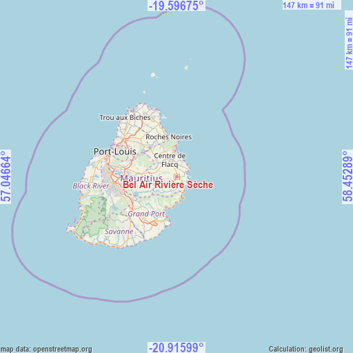
| Map corner | latitude | longitude |
|---|---|---|
| Upper-left | -19.59675°, | 57.04664° |
| Center: | -20.25777°, | 57.74976° |
| Lower-right: | -20.91599°, | 58.45289° |
| Map W x H: | 146.7×146.7 km | = 91.2×91.2mi |
| max Lat: | -10.38803° ⇑61.6% North |
| Bel Air Rivière Sèche: | -20.25777° |
| min Lat: | ⇓38.4% South -20.51667° |
| min Long | Bel Air Rivièr | max Long |
| 56.61795° | 57.74976° | 63.41667° |
| W 91.9%⇐ | ⇒8.1% E |
Elevation
Elevation of Bel Air Rivière Sèche is 78 m = 256 ft, and this is 74.1 m = 243 ft below average elevation for this country.
| Max E: |
467 m = 1532 ft | 57.6% |
| Avg. | 152.1 m = 499 ft | |
| Bel Air Rivière Sèche | 78 m = 256 ft | |
Min E: |
1 m = 3 ft | 42.4% |
See also: Mauritius elevation on elevation.city.
Geographical zone
Bel Air Rivière Sèche is located in South Torrid zone (between Equator and Tropic of Capricorn). Distance of this Southern Tropic circle is 353.5 km =219.7 mi to South.| Distance of | km | miles | from Bel Air Rivière Sèche |
|---|---|---|---|
| Equator | 2252.5 | 1399.6 | to North |
| Tropic Capricorn | 353.5 | 219.7 | to South |
| Antarctic Circle | 5148.7 | 3199.3 | to South |
| South Pole | 7754.6 | 4818.5 | to South |


Nearby cities:
15 places around Bel Air Rivière Sèche: (largest is in red/bold)
• Bambous Virieux
9.5 km =5.9 mi,  175°
175°
• Camp Ithier
4.7 km =2.9 mi,  354°
354°
• Camp de Masque
9.3 km =5.8 mi,  284°
284°
• Centre de Flacq
8.4 km =5.2 mi,  334°
334°
• Clémencia
4.6 km =2.9 mi,  261°
261°
• Ecroignard
3.8 km =2.4 mi,  337°
337°
• Grand Sable
6.5 km =4 mi,  166°
166°
• Grande Rivière Sud Est
4.2 km =2.6 mi,  139°
139°
• Mare La Chaux
6.6 km =4.1 mi,  359°
359°
• Montagne Blanche
10 km =6.2 mi,  252°
252°
• Olivia
3.9 km =2.4 mi,  210°
210°
• Quatre Cocos
6.8 km =4.2 mi,  22°
22°
• Quatre Soeurs
5.1 km =3.2 mi,  154°
154°
• Queen Victoria
6.1 km =3.8 mi,  313°
313°
• Sebastopol
7.4 km =4.6 mi,  240°
240°
Sources, notices
• [Note1] Compared only with cities in Mauritius existing in our database
• [Src1] Map data: © OpenStreetMap contributors (CC-BY-SA)
• [Src2] Other city data from geonames.org with taken over terms of usage.
• [Src3] Geographical zone / Annual Mean Temperature by Robert A. Rohde @ Wikipedia
