Higinio Tanguma geodata
Higinio Tanguma (Tamaulipas) is a populated place; located in Mexico in America/Monterrey (GMT-6) time zone. With population of 527 people, there are 16037 cities with bigger population in this country. Compared to other cities in Mexico, 87.7% of cities are located further ↓South; 60.5% of cities are located further ←West and 79.8% of cities have higher elevation than Higinio Tanguma. Note1


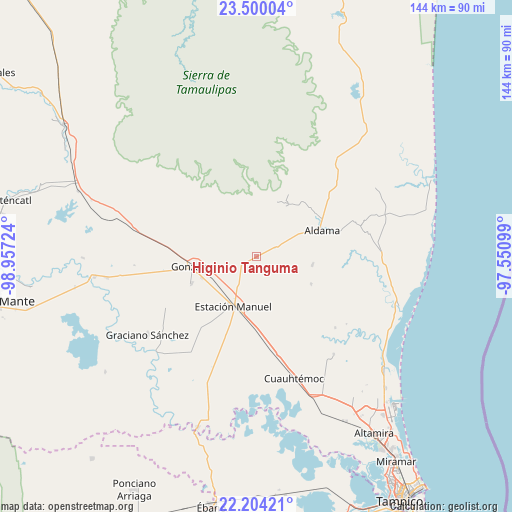
Higinio Tanguma GPS coordinates[2]
22° 51' 13.212" North, 98° 15' 14.796" West
| Map corner | latitude | longitude |
|---|---|---|
| Upper-left | 23.50004°, | -98.95724° |
| Center: | 22.85367°, | -98.25411° |
| Lower-right: | 22.20421°, | -97.55099° |
| Map W x H: | 144.1×144.1 km | = 89.5×89.5mi |
| max Lat: | 32.7° ⇑12.3% North |
| Higinio Tanguma: | 22.85367° |
| min Lat: | ⇓87.7% South 14.53588° |
| min Long | Higinio Tanguma | max Long |
| -117.105° | -98.25411° | -86.73105° |
| W 60.5%⇐ | ⇒39.5% E |
Elevation
Elevation of Higinio Tanguma is 98 m = 322 ft, and this is 1155.7 m = 3792 ft below average elevation for this country.
| Max E: |
3497 m = 11473 ft | 79.8% |
| Avg. | 1253.7 m = 4113 ft | |
| Higinio Tanguma | 98 m = 322 ft | |
Min E: |
-1 m = -3 ft | 20.2% |
See also: Mexico elevation on elevation.city.
Geographical zone
Higinio Tanguma is located in North Torrid zone (between Equator and Tropic of Cancer). Distance of this Northern Tropic circle is 64.8 km =40.3 mi to North.| Distance of | km | miles | from Higinio Tanguma |
|---|---|---|---|
| North Pole | 7466 | 4639.2 | to North |
| Arctic Circle | 4860.1 | 3019.9 | to North |
| Tropic Cancer | 64.8 | 40.3 | to North |
| Equator | 2541.1 | 1579 | to South |


Nearby cities:
15 places around Higinio Tanguma: (largest is in red/bold)
• Adolfo Ruiz Cortines
34 km =21.1 mi,  218°
218°
• Aldama
19.8 km =12.3 mi,  67°
67°
• Benito Juárez
46.6 km =29 mi,  149°
149°
• Cuauhtémoc
36 km =22.4 mi,  162°
162°
• Esteros
39.4 km =24.5 mi, 160°
• Francisco I. Madero
15.8 km =9.8 mi,  99°
99°
• González
18 km =11.2 mi,  260°
260°
• Graciano Sánchez
38 km =23.6 mi,  234°
234°
• José María Luis Mora
35.1 km =21.8 mi,  141°
141°
• López Rayón
44.9 km =27.9 mi,  208°
208°
• Maclovio Herrera
42.9 km =26.7 mi, 156°
• Magiscatzin
46 km =28.6 mi, 262°
• Santa Fe
19.8 km =12.3 mi,  247°
247°
• Tantoyuquita
46.3 km =28.8 mi, 221°
• Ursulo Galván
15.6 km =9.7 mi, 206°
Sources, notices
• [Note1] Compared only with cities in Mexico existing in our database
• [Src1] Map data: © OpenStreetMap contributors (CC-BY-SA)
• [Src2] Other city data from geonames.org with taken over terms of usage.
• [Src3] Geographical zone / Annual Mean Temperature by Robert A. Rohde @ Wikipedia
