Magiscatzin geodata
Magiscatzin (Tamaulipas) is a populated place; located in Mexico in America/Monterrey (GMT-6) time zone. With population of 995 people, there are 8755 cities with bigger population in this country. Compared to other cities in Mexico, 87.6% of cities are located further ↓South; 55.1% of cities are located further ←West and 83.9% of cities have higher elevation than Magiscatzin. Note1


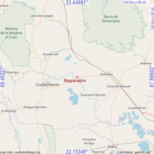
Magiscatzin GPS coordinates[2]
22° 48' 11.484" North, 98° 41' 56.904" West
| Map corner | latitude | longitude |
|---|---|---|
| Upper-left | 23.44981°, | -99.40227° |
| Center: | 22.80319°, | -98.69914° |
| Lower-right: | 22.15349°, | -97.99602° |
| Map W x H: | 144.1×144.1 km | = 89.5×89.5mi |
| max Lat: | 32.7° ⇑12.4% North |
| Magiscatzin: | 22.80319° |
| min Lat: | ⇓87.6% South 14.53588° |
| min Long | Magiscatzin | max Long |
| -117.105° | -98.69914° | -86.73105° |
| W 55.1%⇐ | ⇒44.9% E |
Elevation
Elevation of Magiscatzin is 52 m = 171 ft, and this is 1201.7 m = 3943 ft below average elevation for this country.
| Max E: |
3497 m = 11473 ft | 83.9% |
| Avg. | 1253.7 m = 4113 ft | |
| Magiscatzin | 52 m = 171 ft | |
Min E: |
-1 m = -3 ft | 16.1% |
See also: Mexico elevation on elevation.city.
Geographical zone
Magiscatzin is located in North Torrid zone (between Equator and Tropic of Cancer). Distance of this Northern Tropic circle is 70.4 km =43.7 mi to North.| Distance of | km | miles | from Magiscatzin |
|---|---|---|---|
| North Pole | 7471.6 | 4642.6 | to North |
| Arctic Circle | 4865.7 | 3023.4 | to North |
| Tropic Cancer | 70.4 | 43.7 | to North |
| Equator | 2535.5 | 1575.5 | to South |


Nearby cities:
15 places around Magiscatzin: (largest is in red/bold)
• Adolfo Ruiz Cortines
32.1 km =19.9 mi,  130°
130°
• Ciudad Mante
29 km =18 mi,  256°
256°
• El Camotero Dos
27.1 km =16.8 mi,  173°
173°
• El Limón
31.5 km =19.6 mi,  274°
274°
• Emiliano Zapata
24.1 km =15 mi,  247°
247°
• Emiliano Zapata
31.1 km =19.3 mi,  322°
322°
• González
28 km =17.4 mi,  84°
84°
• Graciano Sánchez
22.2 km =13.8 mi,  138°
138°
• Mártires de Río Blanco
31.6 km =19.6 mi,  275°
275°
• Plan de Ayala
30.1 km =18.7 mi,  193°
193°
• Primero de Mayo
31.1 km =19.3 mi,  304°
304°
• Santa Fe
27.4 km =17 mi,  94°
94°
• Segunda Unidad Xicoténcatl
29.7 km =18.5 mi, 322°
• Tantoyuquita
32.6 km =20.3 mi,  152°
152°
• Venustiano Carranza Dos
6.2 km =3.9 mi,  327°
327°
Sources, notices
• [Note1] Compared only with cities in Mexico existing in our database
• [Src1] Map data: © OpenStreetMap contributors (CC-BY-SA)
• [Src2] Other city data from geonames.org with taken over terms of usage.
• [Src3] Geographical zone / Annual Mean Temperature by Robert A. Rohde @ Wikipedia
