Puhuitzé geodata
Puhuitzé (San Luis Potosí) is a populated place; located in Mexico in America/Mexico_City (GMT-6) time zone. With population of 787 people, there are 11101 cities with bigger population in this country. Compared to other cities in Mexico, 82.3% of cities are located further ↓South; 50.7% of cities are located further →East and 73.9% of cities have higher elevation than Puhuitzé. Note1


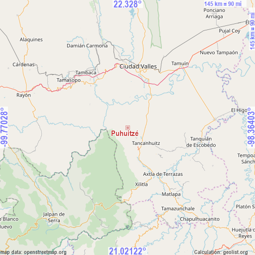
Puhuitzé GPS coordinates[2]
21° 40' 33.924" North, 99° 4' 1.74" West
| Map corner | latitude | longitude |
|---|---|---|
| Upper-left | 22.328°, | -99.77028° |
| Center: | 21.67609°, | -99.06715° |
| Lower-right: | 21.02122°, | -98.36403° |
| Map W x H: | 145.3×145.3 km | = 90.3×90.3mi |
| max Lat: | 32.7° ⇑17.7% North |
| Puhuitzé: | 21.67609° |
| min Lat: | ⇓82.3% South 14.53588° |
| min Long | Puhuitzé | max Long |
| -117.105° | -99.06715° | -86.73105° |
| W 49.3%⇐ | ⇒50.7% E |
Elevation
Elevation of Puhuitzé is 259 m = 850 ft, and this is 994.7 m = 3263 ft below average elevation for this country.
| Max E: |
3497 m = 11473 ft | 73.9% |
| Avg. | 1253.7 m = 4113 ft | |
| Puhuitzé | 259 m = 850 ft | |
Min E: |
-1 m = -3 ft | 26.1% |
See also: Mexico elevation on elevation.city.
Geographical zone
Puhuitzé is located in North Torrid zone (between Equator and Tropic of Cancer). Distance of this Northern Tropic circle is 195.8 km =121.7 mi to North.| Distance of | km | miles | from Puhuitzé |
|---|---|---|---|
| North Pole | 7596.9 | 4720.5 | to North |
| Arctic Circle | 4991 | 3101.3 | to North |
| Tropic Cancer | 195.8 | 121.7 | to North |
| Equator | 2410.2 | 1497.6 | to South |


Nearby cities:
15 places around Puhuitzé: (largest is in red/bold)
• Alitzé
13 km =8.1 mi,  182°
182°
• Aquismón
7.8 km =4.8 mi,  141°
141°
• Lanim
9.8 km =6.1 mi, 138°
• Las Armas
10.5 km =6.5 mi,  77°
77°
• Mantezulel
5.5 km =3.4 mi,  168°
168°
• Octujub o Campeche
13.3 km =8.3 mi,  193°
193°
• Rancho Nuevo
4 km =2.5 mi,  51°
51°
• San José Pequetzén
12.3 km =7.6 mi,  114°
114°
• San Rafael Tamápatz
8.6 km =5.3 mi,  216°
216°
• Tamcuime
10.1 km =6.3 mi, 144°
• Tampate
6.2 km =3.9 mi, 135°
• Tampemoche
2.1 km =1.3 mi,  314°
314°
• Tamápatz
12.2 km =7.6 mi, 185°
• Tanchanaco
2.4 km =1.5 mi, 114°
• Tanute
4 km =2.5 mi,  130°
130°
Sources, notices
• [Note1] Compared only with cities in Mexico existing in our database
• [Src1] Map data: © OpenStreetMap contributors (CC-BY-SA)
• [Src2] Other city data from geonames.org with taken over terms of usage.
• [Src3] Geographical zone / Annual Mean Temperature by Robert A. Rohde @ Wikipedia
