Tampate geodata
Tampate (San Luis Potosí) is a populated place; located in Mexico in America/Mexico_City (GMT-6) time zone. With population of 3,359 people, there are 2704 cities with bigger population in this country. Compared to other cities in Mexico, 82.1% of cities are located further ↓South; 50.2% of cities are located further →East and 81.4% of cities have higher elevation than Tampate. Note1


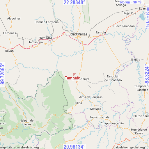
Tampate GPS coordinates[2]
21° 38' 11.004" North, 99° 1' 31.872" West
| Map corner | latitude | longitude |
|---|---|---|
| Upper-left | 22.28848°, | -99.72865° |
| Center: | 21.63639°, | -99.02552° |
| Lower-right: | 20.98134°, | -98.3224° |
| Map W x H: | 145.3×145.3 km | = 90.3×90.3mi |
| max Lat: | 32.7° ⇑17.9% North |
| Tampate: | 21.63639° |
| min Lat: | ⇓82.1% South 14.53588° |
| min Long | Tampate | max Long |
| -117.105° | -99.02552° | -86.73105° |
| W 49.8%⇐ | ⇒50.2% E |
Elevation
Elevation of Tampate is 77 m = 253 ft, and this is 1176.7 m = 3861 ft below average elevation for this country.
| Max E: |
3497 m = 11473 ft | 81.4% |
| Avg. | 1253.7 m = 4113 ft | |
| Tampate | 77 m = 253 ft | |
Min E: |
-1 m = -3 ft | 18.6% |
See also: Mexico elevation on elevation.city.
Geographical zone
Tampate is located in North Torrid zone (between Equator and Tropic of Cancer). Distance of this Northern Tropic circle is 200.2 km =124.4 mi to North.| Distance of | km | miles | from Tampate |
|---|---|---|---|
| North Pole | 7601.3 | 4723.2 | to North |
| Arctic Circle | 4995.4 | 3104 | to North |
| Tropic Cancer | 200.2 | 124.4 | to North |
| Equator | 2405.7 | 1494.8 | to South |


Nearby cities:
15 places around Tampate: (largest is in red/bold)
• Aquismón
1.7 km =1.1 mi,  160°
160°
• Lanim
3.6 km =2.2 mi,  143°
143°
• Las Armas
9 km =5.6 mi,  41°
41°
• Mantezulel
3.3 km =2.1 mi,  252°
252°
• Puhuitzé
6.2 km =3.9 mi,  315°
315°
• Rancho Nuevo
7 km =4.3 mi,  350°
350°
• San José Pequetzén
6.9 km =4.3 mi,  96°
96°
• Santa Bárbara
7.7 km =4.8 mi,  166°
166°
• Tamcuime
4.2 km =2.6 mi, 158°
• Tampemoche
8.3 km =5.2 mi, 315°
• Tamápatz
9.5 km =5.9 mi,  214°
214°
• Tancanhuitz
7.3 km =4.5 mi,  125°
125°
• Tanchanaco
4 km =2.5 mi,  328°
328°
• Tandzumadz
9.2 km =5.7 mi,  149°
149°
• Tanute
2.2 km =1.4 mi, 324°
Sources, notices
• [Note1] Compared only with cities in Mexico existing in our database
• [Src1] Map data: © OpenStreetMap contributors (CC-BY-SA)
• [Src2] Other city data from geonames.org with taken over terms of usage.
• [Src3] Geographical zone / Annual Mean Temperature by Robert A. Rohde @ Wikipedia
