Tanute geodata
Tanute (San Luis Potosí) is a populated place; located in Mexico in America/Mexico_City (GMT-6) time zone. With population of 1,424 people, there are 6068 cities with bigger population in this country. Compared to other cities in Mexico, 82.2% of cities are located further ↓South; 50.4% of cities are located further →East and 82.3% of cities have higher elevation than Tanute. Note1


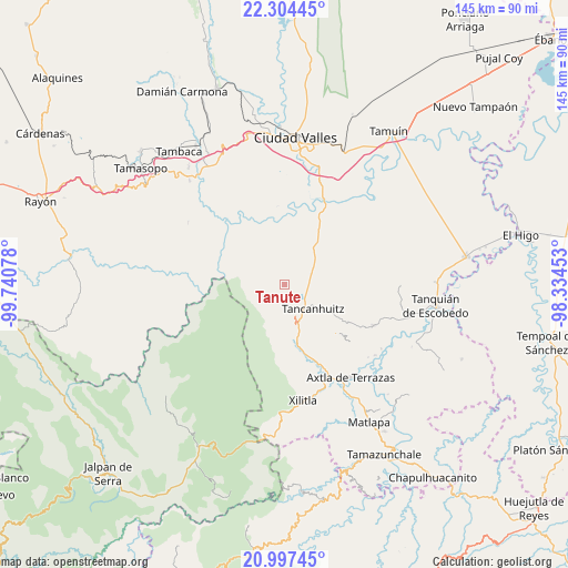
Tanute GPS coordinates[2]
21° 39' 8.748" North, 99° 2' 15.54" West
| Map corner | latitude | longitude |
|---|---|---|
| Upper-left | 22.30445°, | -99.74078° |
| Center: | 21.65243°, | -99.03765° |
| Lower-right: | 20.99745°, | -98.33453° |
| Map W x H: | 145.3×145.3 km | = 90.3×90.3mi |
| max Lat: | 32.7° ⇑17.8% North |
| Tanute: | 21.65243° |
| min Lat: | ⇓82.2% South 14.53588° |
| min Long | Tanute | max Long |
| -117.105° | -99.03765° | -86.73105° |
| W 49.6%⇐ | ⇒50.4% E |
Elevation
Elevation of Tanute is 67 m = 220 ft, and this is 1186.7 m = 3893 ft below average elevation for this country.
| Max E: |
3497 m = 11473 ft | 82.3% |
| Avg. | 1253.7 m = 4113 ft | |
| Tanute | 67 m = 220 ft | |
Min E: |
-1 m = -3 ft | 17.7% |
See also: Mexico elevation on elevation.city.
Geographical zone
Tanute is located in North Torrid zone (between Equator and Tropic of Cancer). Distance of this Northern Tropic circle is 198.4 km =123.3 mi to North.| Distance of | km | miles | from Tanute |
|---|---|---|---|
| North Pole | 7599.5 | 4722.1 | to North |
| Arctic Circle | 4993.6 | 3102.9 | to North |
| Tropic Cancer | 198.4 | 123.3 | to North |
| Equator | 2407.5 | 1496 | to South |


Nearby cities:
15 places around Tanute: (largest is in red/bold)
• Aquismón
3.9 km =2.4 mi,  151°
151°
• Lanim
5.8 km =3.6 mi,  144°
144°
• Las Armas
8.8 km =5.5 mi,  55°
55°
• Mantezulel
3.4 km =2.1 mi,  214°
214°
• Puhuitzé
4 km =2.5 mi,  310°
310°
• Rancho Nuevo
5.1 km =3.2 mi,  0°
0°
• San José Pequetzén
8.5 km =5.3 mi,  107°
107°
• San Rafael Tamápatz
9.2 km =5.7 mi,  242°
242°
• Santa Bárbara
9.8 km =6.1 mi,  162°
162°
• Tamcuime
6.3 km =3.9 mi, 153°
• Tampate
2.2 km =1.4 mi, 144°
• Tampemoche
6.1 km =3.8 mi, 312°
• Tamápatz
10.4 km =6.5 mi,  203°
203°
• Tancanhuitz
9.4 km =5.8 mi,  129°
129°
• Tanchanaco
1.9 km =1.2 mi,  331°
331°
Sources, notices
• [Note1] Compared only with cities in Mexico existing in our database
• [Src1] Map data: © OpenStreetMap contributors (CC-BY-SA)
• [Src2] Other city data from geonames.org with taken over terms of usage.
• [Src3] Geographical zone / Annual Mean Temperature by Robert A. Rohde @ Wikipedia
