Las Palmas geodata
Las Palmas (San Luis Potosí) is a populated place; located in Mexico in America/Mexico_City (GMT-6) time zone. With population of 1,592 people, there are 5427 cities with bigger population in this country. Compared to other cities in Mexico, 84.4% of cities are located further ↓South; 52.4% of cities are located further ←West and 83.5% of cities have higher elevation than Las Palmas. Note1


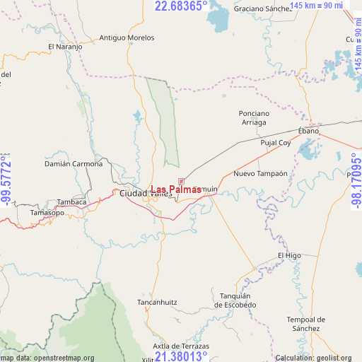
Las Palmas GPS coordinates[2]
22° 2' 0.204" North, 98° 52' 26.652" West
| Map corner | latitude | longitude |
|---|---|---|
| Upper-left | 22.68365°, | -99.5772° |
| Center: | 22.03339°, | -98.87407° |
| Lower-right: | 21.38013°, | -98.17095° |
| Map W x H: | 144.9×144.9 km | = 90×90mi |
| max Lat: | 32.7° ⇑15.6% North |
| Las Palmas: | 22.03339° |
| min Lat: | ⇓84.4% South 14.53588° |
| min Long | Las Palmas | max Long |
| -117.105° | -98.87407° | -86.73105° |
| W 52.4%⇐ | ⇒47.6% E |
Elevation
Elevation of Las Palmas is 55 m = 180 ft, and this is 1198.7 m = 3933 ft below average elevation for this country.
| Max E: |
3497 m = 11473 ft | 83.5% |
| Avg. | 1253.7 m = 4113 ft | |
| Las Palmas | 55 m = 180 ft | |
Min E: |
-1 m = -3 ft | 16.5% |
See also: Mexico elevation on elevation.city.
Geographical zone
Las Palmas is located in North Torrid zone (between Equator and Tropic of Cancer). Distance of this Northern Tropic circle is 156 km =96.9 mi to North.| Distance of | km | miles | from Las Palmas |
|---|---|---|---|
| North Pole | 7557.2 | 4695.8 | to North |
| Arctic Circle | 4951.3 | 3076.6 | to North |
| Tropic Cancer | 156 | 96.9 | to North |
| Equator | 2449.9 | 1522.3 | to South |


Nearby cities:
15 places around Las Palmas: (largest is in red/bold)
• Antiguo Tamuín
12.1 km =7.5 mi,  112°
112°
• Ciudad Valles
14.7 km =9.1 mi,  253°
253°
• Coyoles
24.9 km =15.5 mi,  272°
272°
• Ejido los Huastecos
24.5 km =15.2 mi, 109°
• El Abra (San Felipe)
8.2 km =5.1 mi,  217°
217°
• El Centinela
23.1 km =14.4 mi,  78°
78°
• Emiliano Zapata
16.1 km =10 mi,  16°
16°
• Estación Tamuín
8.1 km =5 mi,  52°
52°
• La Calera
17.5 km =10.9 mi,  206°
206°
• La Fortaleza
10.7 km =6.6 mi,  132°
132°
• Laguna del Mante
23.8 km =14.8 mi,  330°
330°
• Los Sabinos Número Dos
12.9 km =8 mi,  305°
305°
• Nueva Primavera
13.4 km =8.3 mi,  172°
172°
• San Felipe
8.5 km =5.3 mi,  225°
225°
• Tamuín
10.2 km =6.3 mi, 107°
Sources, notices
• [Note1] Compared only with cities in Mexico existing in our database
• [Src1] Map data: © OpenStreetMap contributors (CC-BY-SA)
• [Src2] Other city data from geonames.org with taken over terms of usage.
• [Src3] Geographical zone / Annual Mean Temperature by Robert A. Rohde @ Wikipedia
