Tamuín geodata
Tamuín (San Luis Potosí) is a seat of a second-order administrative division; located in Mexico in America/Mexico_City (GMT-6) time zone. With population of 16,318 people, there are 586 cities with bigger population in this country. Compared to other cities in Mexico, 84.3% of cities are located further ↓South; 53.9% of cities are located further ←West and 89% of cities have higher elevation than Tamuín. Note1


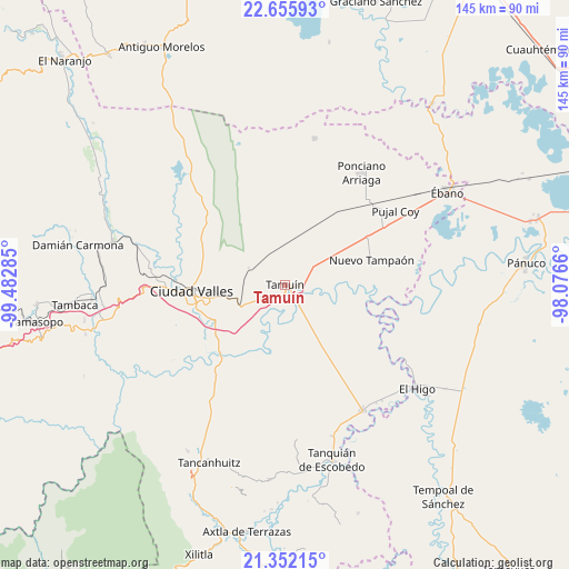
Tamuín GPS coordinates[2]
22° 0' 19.944" North, 98° 46' 46.992" West
| Map corner | latitude | longitude |
|---|---|---|
| Upper-left | 22.65593°, | -99.48285° |
| Center: | 22.00554°, | -98.77972° |
| Lower-right: | 21.35215°, | -98.0766° |
| Map W x H: | 145×145 km | = 90.1×90.1mi |
| max Lat: | 32.7° ⇑15.7% North |
| Tamuín: | 22.00554° |
| min Lat: | ⇓84.3% South 14.53588° |
| min Long | Tamuín | max Long |
| -117.105° | -98.77972° | -86.73105° |
| W 53.9%⇐ | ⇒46.1% E |
Elevation
Elevation of Tamuín is 27 m = 89 ft, and this is 1226.7 m = 4025 ft below average elevation for this country.
| Max E: |
3497 m = 11473 ft | 89% |
| Avg. | 1253.7 m = 4113 ft | |
| Tamuín | 27 m = 89 ft | |
Min E: |
-1 m = -3 ft | 11% |
See also: Mexico elevation on elevation.city.
Geographical zone
Tamuín is located in North Torrid zone (between Equator and Tropic of Cancer). Distance of this Northern Tropic circle is 159.1 km =98.9 mi to North.| Distance of | km | miles | from Tamuín |
|---|---|---|---|
| North Pole | 7560.3 | 4697.8 | to North |
| Arctic Circle | 4954.4 | 3078.5 | to North |
| Tropic Cancer | 159.1 | 98.9 | to North |
| Equator | 2446.8 | 1520.4 | to South |


Nearby cities:
15 places around Tamuín: (largest is in red/bold)
• Antiguo Tamuín
2.1 km =1.3 mi,  138°
138°
• Ciudad Valles
23.9 km =14.9 mi,  267°
267°
• Ejido los Huastecos
14.3 km =8.9 mi,  111°
111°
• El Abra (San Felipe)
15.1 km =9.4 mi,  256°
256°
• El Centinela
15 km =9.3 mi,  59°
59°
• Emiliano Zapata
19.2 km =11.9 mi,  344°
344°
• Estación Tamuín
8.6 km =5.3 mi, 337°
• La Calera
21.6 km =13.4 mi,  234°
234°
• La Fortaleza
4.6 km =2.9 mi,  203°
203°
• Las Palmas
10.2 km =6.3 mi,  287°
287°
• Los Sabinos Número Dos
22.8 km =14.2 mi,  297°
297°
• Nueva Primavera
13 km =8.1 mi,  218°
218°
• Nuevo Ahuacatitla
16.1 km =10 mi,  123°
123°
• Nuevo Tampaón
23 km =14.3 mi,  74°
74°
• San Felipe
16 km =9.9 mi, 259°
Sources, notices
• [Note1] Compared only with cities in Mexico existing in our database
• [Src1] Map data: © OpenStreetMap contributors (CC-BY-SA)
• [Src2] Other city data from geonames.org with taken over terms of usage.
• [Src3] Geographical zone / Annual Mean Temperature by Robert A. Rohde @ Wikipedia
