Santa Elena geodata
Santa Elena (Chiapas) is a populated place; located in Mexico in America/Mexico_City (GMT-6) time zone. With population of 1,508 people, there are 5721 cities with bigger population in this country. Compared to other cities in Mexico, 90.4% of cities are located further ↑North; 96.2% of cities are located further ←West and 65.3% of cities have higher elevation than Santa Elena. Note1


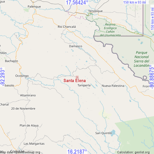
Santa Elena GPS coordinates[2]
16° 53' 33.612" North, 91° 35' 23.532" West
| Map corner | latitude | longitude |
|---|---|---|
| Upper-left | 17.56424°, | -92.293° |
| Center: | 16.89267°, | -91.58987° |
| Lower-right: | 16.2187°, | -90.88675° |
| Map W x H: | 149.6×149.6 km | = 93×93mi |
| max Lat: | 32.7° ⇑90.4% North |
| Santa Elena: | 16.89267° |
| min Lat: | ⇓9.6% South 14.53588° |
| min Long | Santa Elena | max Long |
| -117.105° | -91.58987° | -86.73105° |
| W 96.2%⇐ | ⇒3.8% E |
Elevation
Elevation of Santa Elena is 671 m = 2201 ft, and this is 582.7 m = 1912 ft below average elevation for this country.
| Max E: |
3497 m = 11473 ft | 65.3% |
| Avg. | 1253.7 m = 4113 ft | |
| Santa Elena | 671 m = 2201 ft | |
Min E: |
-1 m = -3 ft | 34.7% |
See also: Mexico elevation on elevation.city.
Geographical zone
Santa Elena is located in North Torrid zone (between Equator and Tropic of Cancer). Distance of this Northern Tropic circle is 727.6 km =452.1 mi to North.| Distance of | km | miles | from Santa Elena |
|---|---|---|---|
| North Pole | 8128.8 | 5051 | to North |
| Arctic Circle | 5522.9 | 3431.8 | to North |
| Tropic Cancer | 727.6 | 452.1 | to North |
| Equator | 1878.3 | 1167.1 | to South |


Nearby cities:
15 places around Santa Elena: (largest is in red/bold)
• Ach Lum Monte Líbano
4 km =2.5 mi,  280°
280°
• Agua Azul
11.2 km =7 mi,  141°
141°
• Cinco de Febrero
18.3 km =11.4 mi,  306°
306°
• El Censo
4.6 km =2.9 mi, 136°
• El Jardín
10.6 km =6.6 mi,  36°
36°
• El Sibal
14.3 km =8.9 mi,  47°
47°
• Lacandón
14.3 km =8.9 mi,  357°
357°
• Las Tazas
15.3 km =9.5 mi,  190°
190°
• Perla de Acapulco
16.1 km =10 mi,  132°
132°
• Plácido Flores
4.8 km =3 mi, 278°
• San Luis (Guadalupe)
6.4 km =4 mi,  317°
317°
• Santa Rita
14.2 km =8.8 mi,  78°
78°
• Santo Tomás
19.1 km =11.9 mi,  167°
167°
• Taniperla
10.6 km =6.6 mi, 137°
• Zaragoza
14 km =8.7 mi,  337°
337°
Sources, notices
• [Note1] Compared only with cities in Mexico existing in our database
• [Src1] Map data: © OpenStreetMap contributors (CC-BY-SA)
• [Src2] Other city data from geonames.org with taken over terms of usage.
• [Src3] Geographical zone / Annual Mean Temperature by Robert A. Rohde @ Wikipedia
