Agua Azul geodata
Agua Azul (Chiapas) is a populated place; located in Mexico in America/Mexico_City (GMT-6) time zone. With population of 1,064 people, there are 8203 cities with bigger population in this country. Compared to other cities in Mexico, 91.5% of cities are located further ↑North; 96.3% of cities are located further ←West and 66% of cities have higher elevation than Agua Azul. Note1


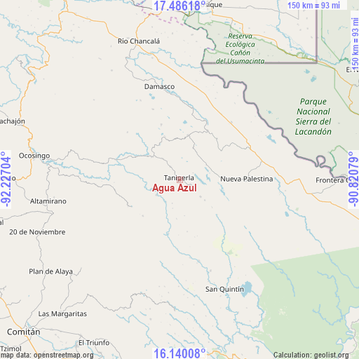
Agua Azul GPS coordinates[2]
16° 48' 51.552" North, 91° 31' 26.076" West
| Map corner | latitude | longitude |
|---|---|---|
| Upper-left | 17.48618°, | -92.22704° |
| Center: | 16.81432°, | -91.52391° |
| Lower-right: | 16.14008°, | -90.82079° |
| Map W x H: | 149.7×149.7 km | = 93×93mi |
| max Lat: | 32.7° ⇑91.5% North |
| Agua Azul: | 16.81432° |
| min Lat: | ⇓8.5% South 14.53588° |
| min Long | Agua Azul | max Long |
| -117.105° | -91.52391° | -86.73105° |
| W 96.3%⇐ | ⇒3.7% E |
Elevation
Elevation of Agua Azul is 637 m = 2090 ft, and this is 616.7 m = 2023 ft below average elevation for this country.
| Max E: |
3497 m = 11473 ft | 66% |
| Avg. | 1253.7 m = 4113 ft | |
| Agua Azul | 637 m = 2090 ft | |
Min E: |
-1 m = -3 ft | 34% |
See also: Mexico elevation on elevation.city.
Geographical zone
Agua Azul is located in North Torrid zone (between Equator and Tropic of Cancer). Distance of this Northern Tropic circle is 736.3 km =457.5 mi to North.| Distance of | km | miles | from Agua Azul |
|---|---|---|---|
| North Pole | 8137.5 | 5056.4 | to North |
| Arctic Circle | 5531.6 | 3437.2 | to North |
| Tropic Cancer | 736.3 | 457.5 | to North |
| Equator | 1869.6 | 1161.7 | to South |


Nearby cities:
15 places around Agua Azul: (largest is in red/bold)
• Ach Lum Monte Líbano
14.5 km =9 mi,  310°
310°
• El Censo
6.6 km =4.1 mi,  324°
324°
• El Jardín
17.3 km =10.7 mi,  357°
357°
• El Sibal
18.7 km =11.6 mi,  10°
10°
• El Zapotal
11.3 km =7 mi,  129°
129°
• Las Tazas
11.6 km =7.2 mi,  236°
236°
• Perla de Acapulco
5.3 km =3.3 mi,  112°
112°
• Plácido Flores
15.1 km =9.4 mi, 308°
• San Caralampio
13.5 km =8.4 mi, 128°
• San José
17.8 km =11.1 mi, 130°
• San Luis (Guadalupe)
17.6 km =10.9 mi, 319°
• Santa Elena
11.2 km =7 mi, 321°
• Santa Rita
13.5 km =8.4 mi,  30°
30°
• Santo Tomás
10.4 km =6.5 mi,  196°
196°
• Taniperla
0.9 km =0.6 mi,  4°
4°
Sources, notices
• [Note1] Compared only with cities in Mexico existing in our database
• [Src1] Map data: © OpenStreetMap contributors (CC-BY-SA)
• [Src2] Other city data from geonames.org with taken over terms of usage.
• [Src3] Geographical zone / Annual Mean Temperature by Robert A. Rohde @ Wikipedia
