Papaloapan geodata
Papaloapan (Puebla) is a populated place; located in Mexico in America/Mexico_City (GMT-6) time zone. With population of 647 people, there are 13375 cities with bigger population in this country. Compared to other cities in Mexico, 72.2% of cities are located further ↑North; 75.7% of cities are located further ←West and 55.5% of cities have higher elevation than Papaloapan. Note1


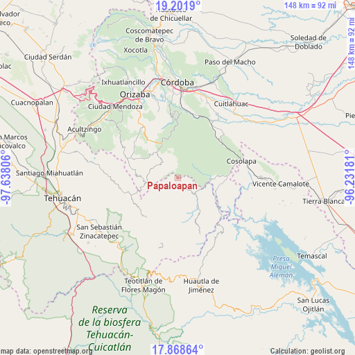
Papaloapan GPS coordinates[2]
18° 32' 11.652" North, 96° 56' 5.748" West
| Map corner | latitude | longitude |
|---|---|---|
| Upper-left | 19.2019°, | -97.63806° |
| Center: | 18.53657°, | -96.93493° |
| Lower-right: | 17.86864°, | -96.23181° |
| Map W x H: | 148.2×148.2 km | = 92.1×92.1mi |
| max Lat: | 32.7° ⇑72.2% North |
| Papaloapan: | 18.53657° |
| min Lat: | ⇓27.8% South 14.53588° |
| min Long | Papaloapan | max Long |
| -117.105° | -96.93493° | -86.73105° |
| W 75.7%⇐ | ⇒24.3% E |
Elevation
Elevation of Papaloapan is 1178 m = 3865 ft, and this is 75.7 m = 248 ft below average elevation for this country.
| Max E: |
3497 m = 11473 ft | 55.5% |
| Avg. | 1253.7 m = 4113 ft | |
| Papaloapan | 1178 m = 3865 ft | |
Min E: |
-1 m = -3 ft | 44.5% |
See also: Mexico elevation on elevation.city.
Geographical zone
Papaloapan is located in North Torrid zone (between Equator and Tropic of Cancer). Distance of this Northern Tropic circle is 544.8 km =338.5 mi to North.| Distance of | km | miles | from Papaloapan |
|---|---|---|---|
| North Pole | 7946 | 4937.4 | to North |
| Arctic Circle | 5340.1 | 3318.2 | to North |
| Tropic Cancer | 544.8 | 338.5 | to North |
| Equator | 2061.1 | 1280.7 | to South |


Nearby cities:
15 places around Papaloapan: (largest is in red/bold)
• Achichinalco
8.1 km =5 mi,  226°
226°
• Achichipico
7 km =4.3 mi,  275°
275°
• Atexacapa
4.4 km =2.7 mi,  238°
238°
• Barrio Segundo
8.7 km =5.4 mi,  319°
319°
• Barrio Tercero
8.6 km =5.3 mi,  311°
311°
• Chiapa
7.8 km =4.8 mi,  187°
187°
• Eloxochitlán
4.5 km =2.8 mi,  205°
205°
• Huitzmaloc
8.9 km =5.5 mi,  183°
183°
• Loma Bonita
7.5 km =4.7 mi,  110°
110°
• Opotzinga
7.9 km =4.9 mi, 284°
• Tepenacaxtla
6.3 km =3.9 mi,  27°
27°
• Tepepan
3.1 km =1.9 mi,  100°
100°
• Tepetlampa
1.9 km =1.2 mi,  356°
356°
• Xonotipan de Juárez
6.3 km =3.9 mi,  140°
140°
• Zapaltecatl
4.6 km =2.9 mi,  16°
16°
Sources, notices
• [Note1] Compared only with cities in Mexico existing in our database
• [Src1] Map data: © OpenStreetMap contributors (CC-BY-SA)
• [Src2] Other city data from geonames.org with taken over terms of usage.
• [Src3] Geographical zone / Annual Mean Temperature by Robert A. Rohde @ Wikipedia
