Tepepan geodata
Tepepan (Puebla) is a populated place; located in Mexico in America/Mexico_City (GMT-6) time zone. With population of 651 people, there are 13306 cities with bigger population in this country. Compared to other cities in Mexico, 72.2% of cities are located further ↑North; 76.1% of cities are located further ←West and 59% of cities have higher elevation than Tepepan. Note1


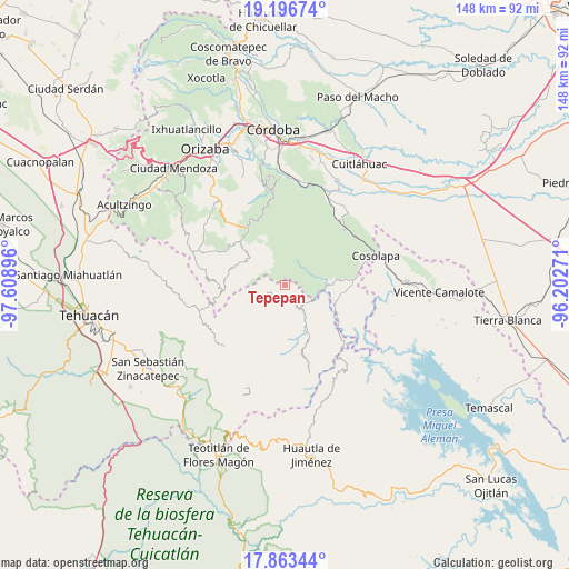
Tepepan GPS coordinates[2]
18° 31' 53.004" North, 96° 54' 20.988" West
| Map corner | latitude | longitude |
|---|---|---|
| Upper-left | 19.19674°, | -97.60896° |
| Center: | 18.53139°, | -96.90583° |
| Lower-right: | 17.86344°, | -96.20271° |
| Map W x H: | 148.2×148.3 km | = 92.1×92.1mi |
| max Lat: | 32.7° ⇑72.2% North |
| Tepepan: | 18.53139° |
| min Lat: | ⇓27.8% South 14.53588° |
| min Long | Tepepan | max Long |
| -117.105° | -96.90583° | -86.73105° |
| W 76.1%⇐ | ⇒23.9% E |
Elevation
Elevation of Tepepan is 1054 m = 3458 ft, and this is 199.7 m = 655 ft below average elevation for this country.
| Max E: |
3497 m = 11473 ft | 59% |
| Avg. | 1253.7 m = 4113 ft | |
| Tepepan | 1054 m = 3458 ft | |
Min E: |
-1 m = -3 ft | 41% |
See also: Mexico elevation on elevation.city.
Geographical zone
Tepepan is located in North Torrid zone (between Equator and Tropic of Cancer). Distance of this Northern Tropic circle is 545.4 km =338.9 mi to North.| Distance of | km | miles | from Tepepan |
|---|---|---|---|
| North Pole | 7946.6 | 4937.8 | to North |
| Arctic Circle | 5340.7 | 3318.6 | to North |
| Tropic Cancer | 545.4 | 338.9 | to North |
| Equator | 2060.5 | 1280.3 | to South |


Nearby cities:
15 places around Tepepan: (largest is in red/bold)
• Achichinalco
10.3 km =6.4 mi,  240°
240°
• Achichipico
10.1 km =6.3 mi,  277°
277°
• Atexacapa
7.1 km =4.4 mi,  255°
255°
• Chiapa
8.3 km =5.2 mi,  209°
209°
• Eloxochitlán
6.1 km =3.8 mi, 235°
• Huitzmaloc
9.1 km =5.7 mi,  203°
203°
• Limonestitla
8.7 km =5.4 mi,  109°
109°
• Loma Bonita
4.5 km =2.8 mi,  116°
116°
• Papaloapan
3.1 km =1.9 mi, 280°
• Tepenacaxtla
6.1 km =3.8 mi,  358°
358°
• Tepetlampa
4 km =2.5 mi,  307°
307°
• Tepetlampa
8.3 km =5.2 mi,  98°
98°
• Tilica
8.8 km =5.5 mi,  76°
76°
• Xonotipan de Juárez
4.4 km =2.7 mi,  168°
168°
• Zapaltecatl
5.3 km =3.3 mi,  340°
340°
Sources, notices
• [Note1] Compared only with cities in Mexico existing in our database
• [Src1] Map data: © OpenStreetMap contributors (CC-BY-SA)
• [Src2] Other city data from geonames.org with taken over terms of usage.
• [Src3] Geographical zone / Annual Mean Temperature by Robert A. Rohde @ Wikipedia
