Xoxocotla geodata
Xoxocotla (Veracruz) is a seat of a second-order administrative division; located in Mexico in America/Mexico_City (GMT-6) time zone. With population of 2,362 people, there are 3741 cities with bigger population in this country. Compared to other cities in Mexico, 70.8% of cities are located further ↑North; 73% of cities are located further ←West and 79.4% of cities have lower elevation than Xoxocotla. Note1


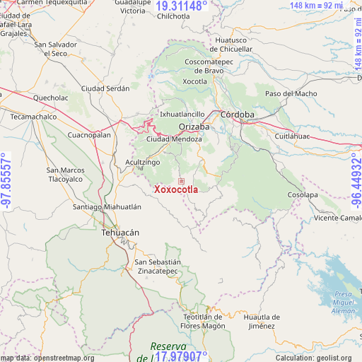
Xoxocotla GPS coordinates[2]
18° 38' 47.688" North, 97° 9' 8.784" West
| Map corner | latitude | longitude |
|---|---|---|
| Upper-left | 19.31148°, | -97.85557° |
| Center: | 18.64658°, | -97.15244° |
| Lower-right: | 17.97907°, | -96.44932° |
| Map W x H: | 148.2×148.2 km | = 92.1×92.1mi |
| max Lat: | 32.7° ⇑70.8% North |
| Xoxocotla: | 18.64658° |
| min Lat: | ⇓29.2% South 14.53588° |
| min Long | Xoxocotla | max Long |
| -117.105° | -97.15244° | -86.73105° |
| W 73%⇐ | ⇒27% E |
Elevation
Elevation of Xoxocotla is 2125 m = 6972 ft, and this is 871.3 m = 2859 ft above average elevation for this country.
| Max E: |
3497 m = 11473 ft | 20.6% |
| Xoxocotla | 2125 m 6972 ft | |
| Avg. | 1253.7 m = 4113 ft | |
Min E: |
-1 m = -3 ft | 79.4% |
See also: Mexico elevation on elevation.city.
Geographical zone
Xoxocotla is located in North Torrid zone (between Equator and Tropic of Cancer). Distance of this Northern Tropic circle is 532.6 km =330.9 mi to North.| Distance of | km | miles | from Xoxocotla |
|---|---|---|---|
| North Pole | 7933.8 | 4929.8 | to North |
| Arctic Circle | 5327.9 | 3310.6 | to North |
| Tropic Cancer | 532.6 | 330.9 | to North |
| Equator | 2073.3 | 1288.3 | to South |


Nearby cities:
15 places around Xoxocotla: (largest is in red/bold)
• Acultzinapa
5.8 km =3.6 mi,  319°
319°
• Alhuaca
8.9 km =5.5 mi,  189°
189°
• Atexcalco
8.2 km =5.1 mi,  336°
336°
• Atlahuilco
8.5 km =5.3 mi,  48°
48°
• Huitzila
8.3 km =5.2 mi,  346°
346°
• Mexcala
5.6 km =3.5 mi, 346°
• Soledad Atzompa
9.4 km =5.8 mi, 338°
• Tepaxapa
3.5 km =2.2 mi,  297°
297°
• Tetlatzinga
6.3 km =3.9 mi,  327°
327°
• Tlaquilpa
5.4 km =3.4 mi,  138°
138°
• Tlatzala
9.2 km =5.7 mi,  7°
7°
• Tlilcalco
1.4 km =0.9 mi,  126°
126°
• Xibtla
8.9 km =5.5 mi,  69°
69°
• Xiquila
8.3 km =5.2 mi, 328°
• Zacamilola
7.6 km =4.7 mi, 71°
Sources, notices
• [Note1] Compared only with cities in Mexico existing in our database
• [Src1] Map data: © OpenStreetMap contributors (CC-BY-SA)
• [Src2] Other city data from geonames.org with taken over terms of usage.
• [Src3] Geographical zone / Annual Mean Temperature by Robert A. Rohde @ Wikipedia
