Zacamilola geodata
Zacamilola (Veracruz) is a populated place; located in Mexico in America/Mexico_City (GMT-6) time zone. With population of 627 people, there are 13802 cities with bigger population in this country. Compared to other cities in Mexico, 70.6% of cities are located further ↑North; 73.8% of cities are located further ←West and 85.8% of cities have lower elevation than Zacamilola. Note1


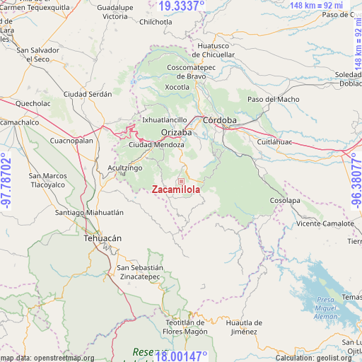
Zacamilola GPS coordinates[2]
18° 40' 8.004" North, 97° 5' 2.004" West
| Map corner | latitude | longitude |
|---|---|---|
| Upper-left | 19.3337°, | -97.78702° |
| Center: | 18.66889°, | -97.08389° |
| Lower-right: | 18.00147°, | -96.38077° |
| Map W x H: | 148.1×148.1 km | = 92×92mi |
| max Lat: | 32.7° ⇑70.6% North |
| Zacamilola: | 18.66889° |
| min Lat: | ⇓29.4% South 14.53588° |
| min Long | Zacamilola | max Long |
| -117.105° | -97.08389° | -86.73105° |
| W 73.8%⇐ | ⇒26.2% E |
Elevation
Elevation of Zacamilola is 2277 m = 7470 ft, and this is 1023.3 m = 3357 ft above average elevation for this country.
| Max E: |
3497 m = 11473 ft | 14.2% |
| Zacamilola | 2277 m 7470 ft | |
| Avg. | 1253.7 m = 4113 ft | |
Min E: |
-1 m = -3 ft | 85.8% |
See also: Mexico elevation on elevation.city.
Geographical zone
Zacamilola is located in North Torrid zone (between Equator and Tropic of Cancer). Distance of this Northern Tropic circle is 530.1 km =329.4 mi to North.| Distance of | km | miles | from Zacamilola |
|---|---|---|---|
| North Pole | 7931.3 | 4928.3 | to North |
| Arctic Circle | 5325.4 | 3309 | to North |
| Tropic Cancer | 530.1 | 329.4 | to North |
| Equator | 2075.8 | 1289.8 | to South |


Nearby cities:
15 places around Zacamilola: (largest is in red/bold)
• Atlahuilco
3.2 km =2 mi,  345°
345°
• Atlanca
4.5 km =2.8 mi,  42°
42°
• Los Reyes
4.3 km =2.7 mi,  87°
87°
• Mexcala
9 km =5.6 mi,  289°
289°
• Santa Cruz
6.7 km =4.2 mi,  5°
5°
• Tepetitlanapa
7.9 km =4.9 mi,  111°
111°
• Tequila
7 km =4.3 mi, 12°
• Texhuacán
6.9 km =4.3 mi,  138°
138°
• Tlalca
6.7 km =4.2 mi, 141°
• Tlaquilpa
7.5 km =4.7 mi,  209°
209°
• Tlatzala
9 km =5.6 mi,  317°
317°
• Tlilcalco
6.9 km =4.3 mi,  241°
241°
• Tolapa
7.9 km =4.9 mi,  0°
0°
• Xibtla
1.3 km =0.8 mi,  59°
59°
• Xoxocotla
7.6 km =4.7 mi,  251°
251°
Sources, notices
• [Note1] Compared only with cities in Mexico existing in our database
• [Src1] Map data: © OpenStreetMap contributors (CC-BY-SA)
• [Src2] Other city data from geonames.org with taken over terms of usage.
• [Src3] Geographical zone / Annual Mean Temperature by Robert A. Rohde @ Wikipedia
