Tetla geodata
Tetla (Veracruz) is a populated place; located in Mexico in America/Mexico_City (GMT-6) time zone. With population of 2,761 people, there are 3205 cities with bigger population in this country. Compared to other cities in Mexico, 64.9% of cities are located further ↑North; 74.1% of cities are located further ←West and 51.7% of cities have lower elevation than Tetla. Note1


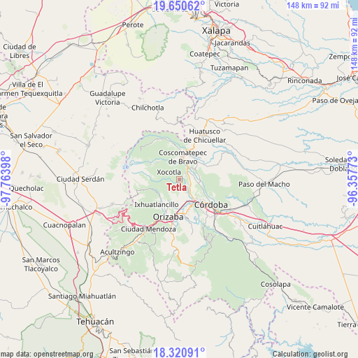
Tetla GPS coordinates[2]
18° 59' 13.524" North, 97° 3' 39.06" West
| Map corner | latitude | longitude |
|---|---|---|
| Upper-left | 19.65062°, | -97.76398° |
| Center: | 18.98709°, | -97.06085° |
| Lower-right: | 18.32091°, | -96.35773° |
| Map W x H: | 147.8×147.9 km | = 91.8×91.9mi |
| max Lat: | 32.7° ⇑64.9% North |
| Tetla: | 18.98709° |
| min Lat: | ⇓35.1% South 14.53588° |
| min Long | Tetla | max Long |
| -117.105° | -97.06085° | -86.73105° |
| W 74.1%⇐ | ⇒25.9% E |
Elevation
Elevation of Tetla is 1513 m = 4964 ft, and this is 259.3 m = 851 ft above average elevation for this country.
| Max E: |
3497 m = 11473 ft | 48.3% |
| Tetla | 1513 m 4964 ft | |
| Avg. | 1253.7 m = 4113 ft | |
Min E: |
-1 m = -3 ft | 51.7% |
See also: Mexico elevation on elevation.city.
Geographical zone
Tetla is located in North Torrid zone (between Equator and Tropic of Cancer). Distance of this Northern Tropic circle is 494.8 km =307.5 mi to North.| Distance of | km | miles | from Tetla |
|---|---|---|---|
| North Pole | 7895.9 | 4906.3 | to North |
| Arctic Circle | 5290 | 3287.1 | to North |
| Tropic Cancer | 494.8 | 307.5 | to North |
| Equator | 2111.2 | 1311.8 | to South |


Nearby cities:
15 places around Tetla: (largest is in red/bold)
• Calaquioco
5.6 km =3.5 mi,  29°
29°
• Chocamán
4 km =2.5 mi,  46°
46°
• Contla
3.7 km =2.3 mi,  255°
255°
• Dos Ríos
5.7 km =3.5 mi,  143°
143°
• Huilotla
5.2 km =3.2 mi,  327°
327°
• La Sidra
6.3 km =3.9 mi,  198°
198°
• Metlac Solano (Metlac Segundo)
6.1 km =3.8 mi,  272°
272°
• Monte Blanco
5.2 km =3.2 mi,  116°
116°
• Rincón Grande
6.1 km =3.8 mi,  220°
220°
• Rincón Pintor
1 km =0.6 mi,  11°
11°
• Santa Lucía Potrerillo
4.3 km =2.7 mi, 117°
• Tetlaxco
5.9 km =3.7 mi,  356°
356°
• Tocuila
6.2 km =3.9 mi,  131°
131°
• Xocotla
5.2 km =3.2 mi,  306°
306°
• Xonotzintla
2.3 km =1.4 mi, 54°
Sources, notices
• [Note1] Compared only with cities in Mexico existing in our database
• [Src1] Map data: © OpenStreetMap contributors (CC-BY-SA)
• [Src2] Other city data from geonames.org with taken over terms of usage.
• [Src3] Geographical zone / Annual Mean Temperature by Robert A. Rohde @ Wikipedia
