Xonotzintla geodata
Xonotzintla (Veracruz) is a populated place; located in Mexico in America/Mexico_City (GMT-6) time zone. With population of 794 people, there are 10982 cities with bigger population in this country. Compared to other cities in Mexico, 64.7% of cities are located further ↑North; 74.3% of cities are located further ←West and 50.2% of cities have higher elevation than Xonotzintla. Note1


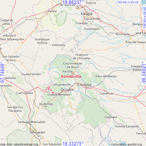
Xonotzintla GPS coordinates[2]
18° 59' 56.004" North, 97° 2' 35.988" West
| Map corner | latitude | longitude |
|---|---|---|
| Upper-left | 19.66237°, | -97.74646° |
| Center: | 18.99889°, | -97.04333° |
| Lower-right: | 18.33275°, | -96.34021° |
| Map W x H: | 147.8×147.8 km | = 91.8×91.8mi |
| max Lat: | 32.7° ⇑64.7% North |
| Xonotzintla: | 18.99889° |
| min Lat: | ⇓35.3% South 14.53588° |
| min Long | Xonotzintla | max Long |
| -117.105° | -97.04333° | -86.73105° |
| W 74.3%⇐ | ⇒25.7% E |
Elevation
Elevation of Xonotzintla is 1420 m = 4659 ft, and this is 166.3 m = 546 ft above average elevation for this country.
| Max E: |
3497 m = 11473 ft | 50.2% |
| Xonotzintla | 1420 m 4659 ft | |
| Avg. | 1253.7 m = 4113 ft | |
Min E: |
-1 m = -3 ft | 49.8% |
See also: Mexico elevation on elevation.city.
Geographical zone
Xonotzintla is located in North Torrid zone (between Equator and Tropic of Cancer). Distance of this Northern Tropic circle is 493.4 km =306.6 mi to North.| Distance of | km | miles | from Xonotzintla |
|---|---|---|---|
| North Pole | 7894.6 | 4905.5 | to North |
| Arctic Circle | 5288.7 | 3286.2 | to North |
| Tropic Cancer | 493.4 | 306.6 | to North |
| Equator | 2112.5 | 1312.6 | to South |


Nearby cities:
15 places around Xonotzintla: (largest is in red/bold)
• Calaquioco
3.6 km =2.2 mi,  14°
14°
• Chocamán
1.8 km =1.1 mi,  36°
36°
• Contla
5.8 km =3.6 mi,  247°
247°
• Huilotla
5.6 km =3.5 mi,  303°
303°
• Monte Blanco
4.6 km =2.9 mi,  142°
142°
• Rincón Pintor
1.7 km =1.1 mi,  259°
259°
• San José Neria
4.7 km =2.9 mi,  97°
97°
• Santa Lucía Potrerillo
3.9 km =2.4 mi,  148°
148°
• Tecama
6.1 km =3.8 mi,  84°
84°
• Tecamilla
6.1 km =3.8 mi,  92°
92°
• Tetla
2.3 km =1.4 mi,  234°
234°
• Tetlaxco
5.1 km =3.2 mi,  334°
334°
• Tocuila
6.1 km =3.8 mi, 152°
• Tomatlán
5 km =3.1 mi, 44°
• Xalatlaco
5.7 km =3.5 mi,  2°
2°
Sources, notices
• [Note1] Compared only with cities in Mexico existing in our database
• [Src1] Map data: © OpenStreetMap contributors (CC-BY-SA)
• [Src2] Other city data from geonames.org with taken over terms of usage.
• [Src3] Geographical zone / Annual Mean Temperature by Robert A. Rohde @ Wikipedia
