El Santiago geodata
El Santiago (Guerrero) is a populated place; located in Mexico in America/Mexico_City (GMT-6) time zone. With population of 669 people, there are 12968 cities with bigger population in this country. Compared to other cities in Mexico, 92.2% of cities are located further ↑North; 61.1% of cities are located further ←West and 71.2% of cities have higher elevation than El Santiago. Note1


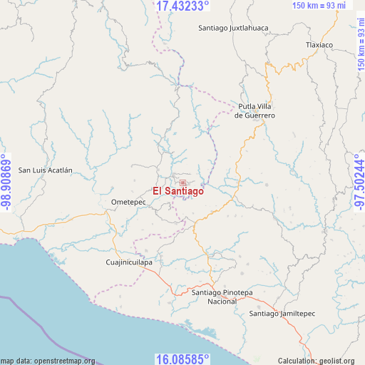
El Santiago GPS coordinates[2]
16° 45' 37.008" North, 98° 12' 20.016" West
| Map corner | latitude | longitude |
|---|---|---|
| Upper-left | 17.43233°, | -98.90869° |
| Center: | 16.76028°, | -98.20556° |
| Lower-right: | 16.08585°, | -97.50244° |
| Map W x H: | 149.7×149.7 km | = 93×93mi |
| max Lat: | 32.7° ⇑92.2% North |
| El Santiago: | 16.76028° |
| min Lat: | ⇓7.8% South 14.53588° |
| min Long | El Santiago | max Long |
| -117.105° | -98.20556° | -86.73105° |
| W 61.1%⇐ | ⇒38.9% E |
Elevation
Elevation of El Santiago is 359 m = 1178 ft, and this is 894.7 m = 2935 ft below average elevation for this country.
| Max E: |
3497 m = 11473 ft | 71.2% |
| Avg. | 1253.7 m = 4113 ft | |
| El Santiago | 359 m = 1178 ft | |
Min E: |
-1 m = -3 ft | 28.8% |
See also: Mexico elevation on elevation.city.
Geographical zone
El Santiago is located in North Torrid zone (between Equator and Tropic of Cancer). Distance of this Northern Tropic circle is 742.4 km =461.3 mi to North.| Distance of | km | miles | from El Santiago |
|---|---|---|---|
| North Pole | 8143.5 | 5060.1 | to North |
| Arctic Circle | 5537.6 | 3440.9 | to North |
| Tropic Cancer | 742.4 | 461.3 | to North |
| Equator | 1863.6 | 1158 | to South |


Nearby cities:
15 places around El Santiago: (largest is in red/bold)
• Arroyo Gente
3.5 km =2.2 mi,  166°
166°
• Buenavista
13.8 km =8.6 mi, 174°
• Colonia Renacimiento
2.5 km =1.6 mi,  83°
83°
• Cruz Verde II
11.7 km =7.3 mi,  233°
233°
• Cumbre de Barranca Honda
14.3 km =8.9 mi,  257°
257°
• Guadalupe Victoria
2.6 km =1.6 mi,  100°
100°
• La Concepción
12.5 km =7.8 mi,  207°
207°
• La Guadalupe
10 km =6.2 mi,  217°
217°
• Los Liros
2.6 km =1.6 mi, 208°
• Plan de Pierna
1.6 km =1 mi,  18°
18°
• Plan de los Muertos
3.2 km =2 mi, 260°
• San Antonio Ocotlán
13 km =8.1 mi,  161°
161°
• Tlacoachistlahuaca
11.6 km =7.2 mi,  298°
298°
• Xochistlahuaca
5.4 km =3.4 mi,  315°
315°
• Zacoalpan
8.9 km =5.5 mi, 258°
Sources, notices
• [Note1] Compared only with cities in Mexico existing in our database
• [Src1] Map data: © OpenStreetMap contributors (CC-BY-SA)
• [Src2] Other city data from geonames.org with taken over terms of usage.
• [Src3] Geographical zone / Annual Mean Temperature by Robert A. Rohde @ Wikipedia
