Xaltepec geodata
Xaltepec (Puebla) is a populated place; located in Mexico in America/Mexico_City (GMT-6) time zone. With population of 8,865 people, there are 1068 cities with bigger population in this country. Compared to other cities in Mexico, 67.5% of cities are located further ↑North; 68.3% of cities are located further ←West and 81.5% of cities have lower elevation than Xaltepec. Note1


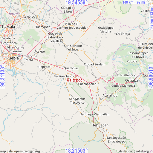
Xaltepec GPS coordinates[2]
18° 52' 53.868" North, 97° 36' 29.7" West
| Map corner | latitude | longitude |
|---|---|---|
| Upper-left | 19.54559°, | -98.31138° |
| Center: | 18.88163°, | -97.60825° |
| Lower-right: | 18.21503°, | -96.90513° |
| Map W x H: | 147.9×147.9 km | = 91.9×91.9mi |
| max Lat: | 32.7° ⇑67.5% North |
| Xaltepec: | 18.88163° |
| min Lat: | ⇓32.5% South 14.53588° |
| min Long | Xaltepec | max Long |
| -117.105° | -97.60825° | -86.73105° |
| W 68.3%⇐ | ⇒31.7% E |
Elevation
Elevation of Xaltepec is 2176 m = 7139 ft, and this is 922.3 m = 3026 ft above average elevation for this country.
| Max E: |
3497 m = 11473 ft | 18.5% |
| Xaltepec | 2176 m 7139 ft | |
| Avg. | 1253.7 m = 4113 ft | |
Min E: |
-1 m = -3 ft | 81.5% |
See also: Mexico elevation on elevation.city.
Geographical zone
Xaltepec is located in North Torrid zone (between Equator and Tropic of Cancer). Distance of this Northern Tropic circle is 506.5 km =314.7 mi to North.| Distance of | km | miles | from Xaltepec |
|---|---|---|---|
| North Pole | 7907.6 | 4913.6 | to North |
| Arctic Circle | 5301.7 | 3294.3 | to North |
| Tropic Cancer | 506.5 | 314.7 | to North |
| Equator | 2099.4 | 1304.5 | to South |


Nearby cities:
15 places around Xaltepec: (largest is in red/bold)
• Bellavista de Victoria (San José Bellavista)
6.8 km =4.2 mi,  94°
94°
• Francisco I. Madero
9.6 km =6 mi,  304°
304°
• Guadalupe Enríquez
2.6 km =1.6 mi,  58°
58°
• Jesús Nazareno
1.7 km =1.1 mi,  250°
250°
• La Purísima
6.9 km =4.3 mi,  147°
147°
• Palmar de Bravo
8.2 km =5.1 mi,  128°
128°
• Palmarito Tochapan
3.8 km =2.4 mi, 304°
• Quecholac
9.7 km =6 mi,  326°
326°
• San Bartolomé
4.2 km =2.6 mi,  344°
344°
• San Cayetano
5 km =3.1 mi, 329°
• San Isidro Monterrosas
4.4 km =2.7 mi, 128°
• San Pedro Temamatla
11.2 km =7 mi, 64°
• Santa Cruz Monterrosas
4.9 km =3 mi,  97°
97°
• Tuzuapan
6.5 km =4 mi,  289°
289°
• Yehualtepec
11.1 km =6.9 mi,  210°
210°
Sources, notices
• [Note1] Compared only with cities in Mexico existing in our database
• [Src1] Map data: © OpenStreetMap contributors (CC-BY-SA)
• [Src2] Other city data from geonames.org with taken over terms of usage.
• [Src3] Geographical zone / Annual Mean Temperature by Robert A. Rohde @ Wikipedia
