Yehualtepec geodata
Yehualtepec (Puebla) is a seat of a second-order administrative division; located in Mexico in America/Mexico_City (GMT-6) time zone. With population of 6,903 people, there are 1350 cities with bigger population in this country. Compared to other cities in Mexico, 68.8% of cities are located further ↑North; 67.8% of cities are located further ←West and 79.6% of cities have lower elevation than Yehualtepec. Note1


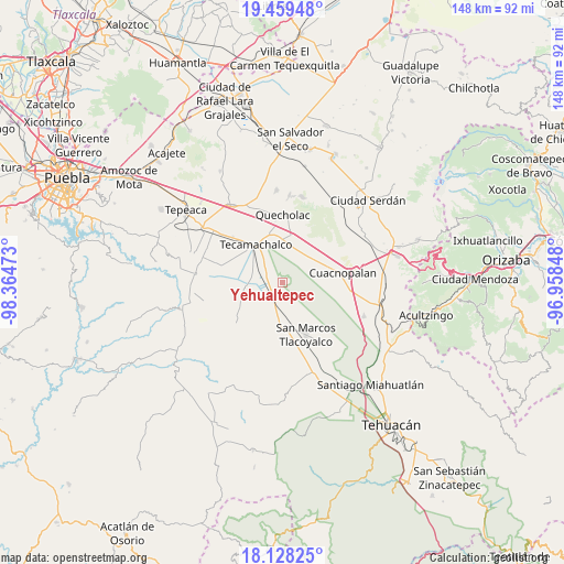
Yehualtepec GPS coordinates[2]
18° 47' 42.648" North, 97° 39' 41.76" West
| Map corner | latitude | longitude |
|---|---|---|
| Upper-left | 19.45948°, | -98.36473° |
| Center: | 18.79518°, | -97.6616° |
| Lower-right: | 18.12825°, | -96.95848° |
| Map W x H: | 148×148 km | = 92×92mi |
| max Lat: | 32.7° ⇑68.8% North |
| Yehualtepec: | 18.79518° |
| min Lat: | ⇓31.2% South 14.53588° |
| min Long | Yehualtepec | max Long |
| -117.105° | -97.6616° | -86.73105° |
| W 67.8%⇐ | ⇒32.2% E |
Elevation
Elevation of Yehualtepec is 2130 m = 6988 ft, and this is 876.3 m = 2875 ft above average elevation for this country.
| Max E: |
3497 m = 11473 ft | 20.4% |
| Yehualtepec | 2130 m 6988 ft | |
| Avg. | 1253.7 m = 4113 ft | |
Min E: |
-1 m = -3 ft | 79.6% |
See also: Mexico elevation on elevation.city.
Geographical zone
Yehualtepec is located in North Torrid zone (between Equator and Tropic of Cancer). Distance of this Northern Tropic circle is 516.1 km =320.7 mi to North.| Distance of | km | miles | from Yehualtepec |
|---|---|---|---|
| North Pole | 7917.2 | 4919.5 | to North |
| Arctic Circle | 5311.3 | 3300.3 | to North |
| Tropic Cancer | 516.1 | 320.7 | to North |
| Equator | 2089.8 | 1298.5 | to South |


Nearby cities:
15 places around Yehualtepec: (largest is in red/bold)
• Jesús Nazareno
9.9 km =6.2 mi,  24°
24°
• La Laguna
7.9 km =4.9 mi,  273°
273°
• La Purísima
10.1 km =6.3 mi,  67°
67°
• Los Marías
8.2 km =5.1 mi,  180°
180°
• Ocotlán de Venustiano Carranza
0.9 km =0.6 mi,  240°
240°
• Rancho Chico
5.4 km =3.4 mi, 183°
• Rubén Jaramillo
10.6 km =6.6 mi,  293°
293°
• San Baltazar
9.9 km =6.2 mi,  263°
263°
• San Gabriel Tetzoyocán
6.1 km =3.8 mi,  226°
226°
• San José Tlacuitlapan
10.5 km =6.5 mi,  158°
158°
• San Miguel Zozutla
4.6 km =2.9 mi,  171°
171°
• Santiago Alseseca
7.3 km =4.5 mi,  319°
319°
• Tecalzingo
9.2 km =5.7 mi,  186°
186°
• Tlacomulco
6.5 km =4 mi, 174°
• Xochimilco
8.5 km =5.3 mi,  307°
307°
Sources, notices
• [Note1] Compared only with cities in Mexico existing in our database
• [Src1] Map data: © OpenStreetMap contributors (CC-BY-SA)
• [Src2] Other city data from geonames.org with taken over terms of usage.
• [Src3] Geographical zone / Annual Mean Temperature by Robert A. Rohde @ Wikipedia
