Mazoco geodata
Mazoco (Veracruz) is a populated place; located in Mexico in America/Mexico_City (GMT-6) time zone. With population of 975 people, there are 8909 cities with bigger population in this country. Compared to other cities in Mexico, 77.9% of cities are located further ↑North; 83% of cities are located further ←West and 89.4% of cities have higher elevation than Mazoco. Note1


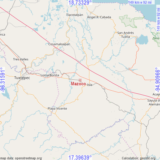
Mazoco GPS coordinates[2]
18° 3' 57.996" North, 95° 36' 46.008" West
| Map corner | latitude | longitude |
|---|---|---|
| Upper-left | 18.73329°, | -96.31591° |
| Center: | 18.06611°, | -95.61278° |
| Lower-right: | 17.39639°, | -94.90966° |
| Map W x H: | 148.6×148.7 km | = 92.3×92.4mi |
| max Lat: | 32.7° ⇑77.9% North |
| Mazoco: | 18.06611° |
| min Lat: | ⇓22.1% South 14.53588° |
| min Long | Mazoco | max Long |
| -117.105° | -95.61278° | -86.73105° |
| W 83%⇐ | ⇒17% E |
Elevation
Elevation of Mazoco is 26 m = 85 ft, and this is 1227.7 m = 4028 ft below average elevation for this country.
| Max E: |
3497 m = 11473 ft | 89.4% |
| Avg. | 1253.7 m = 4113 ft | |
| Mazoco | 26 m = 85 ft | |
Min E: |
-1 m = -3 ft | 10.6% |
See also: Mexico elevation on elevation.city.
Geographical zone
Mazoco is located in North Torrid zone (between Equator and Tropic of Cancer). Distance of this Northern Tropic circle is 597.2 km =371.1 mi to North.| Distance of | km | miles | from Mazoco |
|---|---|---|---|
| North Pole | 7998.3 | 4969.9 | to North |
| Arctic Circle | 5392.4 | 3350.7 | to North |
| Tropic Cancer | 597.2 | 371.1 | to North |
| Equator | 2008.8 | 1248.2 | to South |


Nearby cities:
15 places around Mazoco: (largest is in red/bold)
• Cujuliapan
15.7 km =9.8 mi,  343°
343°
• Curazao
8.8 km =5.5 mi,  297°
297°
• El Maguey
9.3 km =5.8 mi,  274°
274°
• El Marcial
12 km =7.5 mi,  218°
218°
• El Paraíso
11.2 km =7 mi,  110°
110°
• Estación Dobladero
17.1 km =10.6 mi,  288°
288°
• Isla
9.8 km =6.1 mi,  115°
115°
• La Unión
16.2 km =10.1 mi,  74°
74°
• Las Mesas
18.5 km =11.5 mi,  321°
321°
• Lindavista
17.4 km =10.8 mi,  278°
278°
• Loma Alta
10 km =6.2 mi,  193°
193°
• Nuevo Potrero
4.3 km =2.7 mi,  6°
6°
• San Jerónimo
13 km =8.1 mi,  225°
225°
• Tesechoacan
9.3 km =5.8 mi,  328°
328°
• Villa Azueta
10.6 km =6.6 mi, 274°
Sources, notices
• [Note1] Compared only with cities in Mexico existing in our database
• [Src1] Map data: © OpenStreetMap contributors (CC-BY-SA)
• [Src2] Other city data from geonames.org with taken over terms of usage.
• [Src3] Geographical zone / Annual Mean Temperature by Robert A. Rohde @ Wikipedia
