San Andrés geodata
San Andrés (Hidalgo) is a populated place; located in Mexico in America/Mexico_City (GMT-6) time zone. With population of 1,132 people, there are 7659 cities with bigger population in this country. Compared to other cities in Mexico, 67.8% of cities are located further ↓South; 62.5% of cities are located further ←West and 54% of cities have higher elevation than San Andrés. Note1


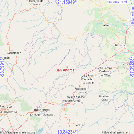
San Andrés GPS coordinates[2]
20° 30' 8.388" North, 98° 5' 45.6" West
| Map corner | latitude | longitude |
|---|---|---|
| Upper-left | 21.15949°, | -98.79913° |
| Center: | 20.50233°, | -98.096° |
| Lower-right: | 19.84234°, | -97.39288° |
| Map W x H: | 146.5×146.5 km | = 91×91mi |
| max Lat: | 32.7° ⇑32.2% North |
| San Andrés: | 20.50233° |
| min Lat: | ⇓67.8% South 14.53588° |
| min Long | San Andrés | max Long |
| -117.105° | -98.096° | -86.73105° |
| W 62.5%⇐ | ⇒37.5% E |
Elevation
Elevation of San Andrés is 1241 m = 4072 ft, and this is 12.7 m = 42 ft below average elevation for this country.
| Max E: |
3497 m = 11473 ft | 54% |
| Avg. | 1253.7 m = 4113 ft | |
| San Andrés | 1241 m = 4072 ft | |
Min E: |
-1 m = -3 ft | 46% |
See also: Mexico elevation on elevation.city.
Geographical zone
San Andrés is located in North Torrid zone (between Equator and Tropic of Cancer). Distance of this Northern Tropic circle is 326.3 km =202.8 mi to North.| Distance of | km | miles | from San Andrés |
|---|---|---|---|
| North Pole | 7727.4 | 4801.6 | to North |
| Arctic Circle | 5121.5 | 3182.4 | to North |
| Tropic Cancer | 326.3 | 202.8 | to North |
| Equator | 2279.6 | 1416.5 | to South |


Nearby cities:
15 places around San Andrés: (largest is in red/bold)
• Acalmán
9.8 km =6.1 mi,  156°
156°
• Acuautla
6.6 km =4.1 mi,  101°
101°
• Barrio Aztlán
4.2 km =2.6 mi,  165°
165°
• El Ocotal
11.6 km =7.2 mi,  178°
178°
• Huehuetla
5.1 km =3.2 mi, 156°
• Juntas Chicas
10.5 km =6.5 mi,  40°
40°
• San Ambrosio
8.3 km =5.2 mi,  69°
69°
• San Antonio el Grande
8.1 km =5 mi,  128°
128°
• San Esteban
6 km =3.7 mi, 38°
• San Francisco
11.3 km =7 mi,  60°
60°
• San Gregorio
8.1 km =5 mi,  93°
93°
• San Lorenzo Achiotepec
10.9 km =6.8 mi,  15°
15°
• Santa Inés
5.2 km =3.2 mi, 174°
• Santa Úrsula
9.2 km =5.7 mi,  185°
185°
• Tlaxco
11.2 km =7 mi,  141°
141°
Sources, notices
• [Note1] Compared only with cities in Mexico existing in our database
• [Src1] Map data: © OpenStreetMap contributors (CC-BY-SA)
• [Src2] Other city data from geonames.org with taken over terms of usage.
• [Src3] Geographical zone / Annual Mean Temperature by Robert A. Rohde @ Wikipedia
