Totolapan geodata
Totolapan (Morelos) is a populated place; located in Mexico in America/Mexico_City (GMT-6) time zone. With population of 6,198 people, there are 1502 cities with bigger population in this country. Compared to other cities in Mexico, 65% of cities are located further ↑North; 51.6% of cities are located further ←West and 68.7% of cities have lower elevation than Totolapan. Note1


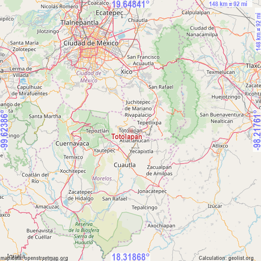
Totolapan GPS coordinates[2]
18° 59' 5.532" North, 98° 55' 14.628" West
| Map corner | latitude | longitude |
|---|---|---|
| Upper-left | 19.64841°, | -99.62386° |
| Center: | 18.98487°, | -98.92073° |
| Lower-right: | 18.31868°, | -98.21761° |
| Map W x H: | 147.9×147.9 km | = 91.9×91.9mi |
| max Lat: | 32.7° ⇑65% North |
| Totolapan: | 18.98487° |
| min Lat: | ⇓35% South 14.53588° |
| min Long | Totolapan | max Long |
| -117.105° | -98.92073° | -86.73105° |
| W 51.6%⇐ | ⇒48.4% E |
Elevation
Elevation of Totolapan is 1902 m = 6240 ft, and this is 648.3 m = 2127 ft above average elevation for this country.
| Max E: |
3497 m = 11473 ft | 31.3% |
| Totolapan | 1902 m 6240 ft | |
| Avg. | 1253.7 m = 4113 ft | |
Min E: |
-1 m = -3 ft | 68.7% |
See also: Mexico elevation on elevation.city.
Geographical zone
Totolapan is located in North Torrid zone (between Equator and Tropic of Cancer). Distance of this Northern Tropic circle is 495 km =307.6 mi to North.| Distance of | km | miles | from Totolapan |
|---|---|---|---|
| North Pole | 7896.1 | 4906.4 | to North |
| Arctic Circle | 5290.3 | 3287.2 | to North |
| Tropic Cancer | 495 | 307.6 | to North |
| Equator | 2110.9 | 1311.7 | to South |


Nearby cities:
15 places around Totolapan: (largest is in red/bold)
• Ahuatlán (Asunción Ahuatlán)
1.5 km =0.9 mi,  319°
319°
• Amatlipac (San Agustín Amatlipac)
5.2 km =3.2 mi,  269°
269°
• Atlatlahucan
6.1 km =3.8 mi,  157°
157°
• Colonia Kilómetro 88
7.2 km =4.5 mi,  151°
151°
• Cuauhtempan (San Andrés Cuauhtempan)
2.9 km =1.8 mi,  247°
247°
• El Pedregal
7 km =4.3 mi,  289°
289°
• El Vigía
5 km =3.1 mi,  305°
305°
• Emiliano Zapata (Casahuates)
7.3 km =4.5 mi,  213°
213°
• Felipe Neri (Cuatepec)
6.5 km =4 mi,  338°
338°
• La Cañada (San Sebastián)
4.9 km =3 mi,  278°
278°
• Nacatongo
7.6 km =4.7 mi,  234°
234°
• Nepopualco
2.8 km =1.7 mi,  304°
304°
• San Juan Texcalpan
5.5 km =3.4 mi,  188°
188°
• Tlaltetelco (San Miguel Tlaltetelco)
5 km =3.1 mi,  136°
136°
• Tlayacapan
7.1 km =4.4 mi,  242°
242°
Sources, notices
• [Note1] Compared only with cities in Mexico existing in our database
• [Src1] Map data: © OpenStreetMap contributors (CC-BY-SA)
• [Src2] Other city data from geonames.org with taken over terms of usage.
• [Src3] Geographical zone / Annual Mean Temperature by Robert A. Rohde @ Wikipedia
