El Pedregal geodata
El Pedregal (Morelos) is a populated place; located in Mexico in America/Mexico_City (GMT-6) time zone. With population of 507 people, there are 16589 cities with bigger population in this country. Compared to other cities in Mexico, 64.6% of cities are located further ↑North; 50.5% of cities are located further ←West and 72.8% of cities have lower elevation than El Pedregal. Note1


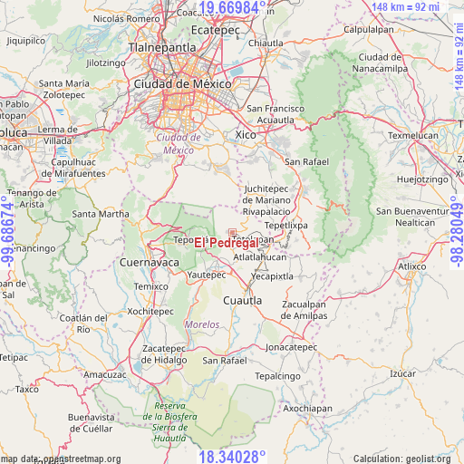
El Pedregal GPS coordinates[2]
19° 0' 23.004" North, 98° 59' 0.996" West
| Map corner | latitude | longitude |
|---|---|---|
| Upper-left | 19.66984°, | -99.68674° |
| Center: | 19.00639°, | -98.98361° |
| Lower-right: | 18.34028°, | -98.28049° |
| Map W x H: | 147.8×147.8 km | = 91.8×91.8mi |
| max Lat: | 32.7° ⇑64.6% North |
| El Pedregal: | 19.00639° |
| min Lat: | ⇓35.4% South 14.53588° |
| min Long | El Pedregal | max Long |
| -117.105° | -98.98361° | -86.73105° |
| W 50.5%⇐ | ⇒49.5% E |
Elevation
Elevation of El Pedregal is 1984 m = 6509 ft, and this is 730.3 m = 2396 ft above average elevation for this country.
| Max E: |
3497 m = 11473 ft | 27.2% |
| El Pedregal | 1984 m 6509 ft | |
| Avg. | 1253.7 m = 4113 ft | |
Min E: |
-1 m = -3 ft | 72.8% |
See also: Mexico elevation on elevation.city.
Geographical zone
El Pedregal is located in North Torrid zone (between Equator and Tropic of Cancer). Distance of this Northern Tropic circle is 492.6 km =306.1 mi to North.| Distance of | km | miles | from El Pedregal |
|---|---|---|---|
| North Pole | 7893.7 | 4904.9 | to North |
| Arctic Circle | 5287.9 | 3285.7 | to North |
| Tropic Cancer | 492.6 | 306.1 | to North |
| Equator | 2113.3 | 1313.1 | to South |


Nearby cities:
15 places around El Pedregal: (largest is in red/bold)
• Ahuatlán (Asunción Ahuatlán)
5.8 km =3.6 mi,  102°
102°
• Amatlipac (San Agustín Amatlipac)
2.9 km =1.8 mi,  149°
149°
• Amatlán de Quetzalcoatl
6.6 km =4.1 mi,  238°
238°
• Cuauhtempan (San Andrés Cuauhtempan)
5.3 km =3.3 mi,  131°
131°
• El Golán
7.8 km =4.8 mi,  199°
199°
• El Vigía
2.6 km =1.6 mi,  78°
78°
• Felipe Neri (Cuatepec)
5.6 km =3.5 mi,  48°
48°
• Ignacio Bastida (Santa Catarina Tlayca)
8 km =5 mi, 203°
• La Cañada (San Sebastián)
2.4 km =1.5 mi, 133°
• Nacatongo
6.8 km =4.2 mi,  176°
176°
• Nepopualco
4.4 km =2.7 mi, 100°
• Santo Domingo Ocotitlán
8.2 km =5.1 mi,  276°
276°
• Tlalnepantla
1.3 km =0.8 mi, 281°
• Tlayacapan
5.7 km =3.5 mi, 177°
• Totolapan
7 km =4.3 mi,  109°
109°
Sources, notices
• [Note1] Compared only with cities in Mexico existing in our database
• [Src1] Map data: © OpenStreetMap contributors (CC-BY-SA)
• [Src2] Other city data from geonames.org with taken over terms of usage.
• [Src3] Geographical zone / Annual Mean Temperature by Robert A. Rohde @ Wikipedia
