La Cañada (San Sebastián) geodata
La Cañada (San Sebastián) (Morelos) is a populated place; located in Mexico in America/Mexico_City (GMT-6) time zone. With population of 506 people, there are 16626 cities with bigger population in this country. Compared to other cities in Mexico, 64.9% of cities are located further ↑North; 50.8% of cities are located further ←West and 65% of cities have lower elevation than La Cañada (San Sebastián). Note1
Current local time in La Cañada (San Sebastián):
08:34 AM, WednesdayDifference from your time zone: hours


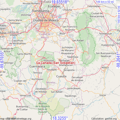
La Cañada (San Sebastián) GPS coordinates[2]
18° 59' 30.012" North, 98° 58' 1.992" West
| Map corner | latitude | longitude |
|---|---|---|
| Upper-left | 19.65518°, | -99.67035° |
| Center: | 18.99167°, | -98.96722° |
| Lower-right: | 18.3255°, | -98.2641° |
| Map W x H: | 147.8×147.8 km | = 91.8×91.8mi |
| max Lat: | 32.7° ⇑64.9% North |
| La Cañada (San Sebastián): | 18.99167° |
| min Lat: | ⇓35.1% South 14.53588° |
| min Long | La Cañada (San | max Long |
| -117.105° | -98.96722° | -86.73105° |
| W 50.8%⇐ | ⇒49.2% E |
Elevation
Elevation of La Cañada (San Sebastián) is 1829 m = 6001 ft, and this is 575.3 m = 1887 ft above average elevation for this country.
| Max E: |
3497 m = 11473 ft | 35% |
| La Cañada (San Sebastián) | 1829 m 6001 ft | |
| Avg. | 1253.7 m = 4113 ft | |
Min E: |
-1 m = -3 ft | 65% |
See also: Mexico elevation on elevation.city.
Geographical zone
La Cañada (San Sebastián) is located in North Torrid zone (between Equator and Tropic of Cancer). Distance of this Northern Tropic circle is 494.2 km =307.1 mi to North.| Distance of | km | miles | from La Cañada (San Sebastián) |
|---|---|---|---|
| North Pole | 7895.4 | 4906 | to North |
| Arctic Circle | 5289.5 | 3286.7 | to North |
| Tropic Cancer | 494.2 | 307.1 | to North |
| Equator | 2111.7 | 1312.1 | to South |


Nearby cities:
15 places around La Cañada (San Sebastián): (largest is in red/bold)
• Ahuatlán (Asunción Ahuatlán)
4 km =2.5 mi,  84°
84°
• Amatlipac (San Agustín Amatlipac)
0.9 km =0.6 mi,  199°
199°
• Corral Grande
7 km =4.3 mi,  182°
182°
• Cuauhtempan (San Andrés Cuauhtempan)
2.9 km =1.8 mi,  130°
130°
• El Golán
7.2 km =4.5 mi,  217°
217°
• El Pedregal
2.4 km =1.5 mi,  313°
313°
• El Vigía
2.3 km =1.4 mi,  20°
20°
• Emiliano Zapata (Casahuates)
6.9 km =4.3 mi,  172°
172°
• Felipe Neri (Cuatepec)
5.9 km =3.7 mi,  25°
25°
• Nacatongo
5.3 km =3.3 mi,  194°
194°
• Nepopualco
2.7 km =1.7 mi,  71°
71°
• San Juan Texcalpan
7.4 km =4.6 mi,  147°
147°
• Tlalnepantla
3.6 km =2.2 mi,  302°
302°
• Tlayacapan
4.3 km =2.7 mi, 199°
• Totolapan
4.9 km =3 mi,  98°
98°
Sources, notices
• [Note1] Compared only with cities in Mexico existing in our database
• [Src1] Map data: © OpenStreetMap contributors (CC-BY-SA)
• [Src2] Other city data from geonames.org with taken over terms of usage.
• [Src3] Geographical zone / Annual Mean Temperature by Robert A. Rohde @ Wikipedia
