Tlaxco geodata
Tlaxco (Tlaxcala) is a seat of a second-order administrative division; located in Mexico in America/Mexico_City (GMT-6) time zone. With population of 14,806 people, there are 654 cities with bigger population in this country. Compared to other cities in Mexico, 51.6% of cities are located further ↑North; 62.3% of cities are located further ←West and 93.5% of cities have lower elevation than Tlaxco. Note1


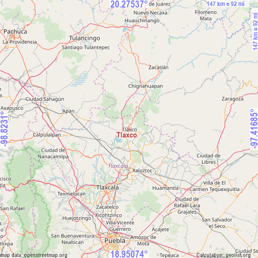
Tlaxco GPS coordinates[2]
19° 36' 51.912" North, 98° 7' 11.892" West
| Map corner | latitude | longitude |
|---|---|---|
| Upper-left | 20.27537°, | -98.8231° |
| Center: | 19.61442°, | -98.11997° |
| Lower-right: | 18.95074°, | -97.41685° |
| Map W x H: | 147.3×147.3 km | = 91.5×91.5mi |
| max Lat: | 32.7° ⇑51.6% North |
| Tlaxco: | 19.61442° |
| min Lat: | ⇓48.4% South 14.53588° |
| min Long | Tlaxco | max Long |
| -117.105° | -98.11997° | -86.73105° |
| W 62.3%⇐ | ⇒37.7% E |
Elevation
Elevation of Tlaxco is 2550 m = 8366 ft, and this is 1296.3 m = 4253 ft above average elevation for this country.
| Max E: |
3497 m = 11473 ft | 6.5% |
| Tlaxco | 2550 m 8366 ft | |
| Avg. | 1253.7 m = 4113 ft | |
Min E: |
-1 m = -3 ft | 93.5% |
See also: Mexico elevation on elevation.city.
Geographical zone
Tlaxco is located in North Torrid zone (between Equator and Tropic of Cancer). Distance of this Northern Tropic circle is 425 km =264.1 mi to North.| Distance of | km | miles | from Tlaxco |
|---|---|---|---|
| North Pole | 7826.1 | 4862.9 | to North |
| Arctic Circle | 5220.3 | 3243.7 | to North |
| Tropic Cancer | 425 | 264.1 | to North |
| Equator | 2180.9 | 1355.1 | to South |


Nearby cities:
15 places around Tlaxco: (largest is in red/bold)
• Acopinalco del Peñón
6.7 km =4.2 mi,  317°
317°
• Atlangatepec
13.1 km =8.1 mi,  225°
225°
• Calpanería Atezquilla
13.8 km =8.6 mi,  70°
70°
• Capula
11.9 km =7.4 mi,  136°
136°
• Casa Blanca
13.8 km =8.6 mi,  292°
292°
• El Fresno
13.6 km =8.5 mi,  18°
18°
• El Rosario
12.5 km =7.8 mi, 294°
• José María Morelos y Pavón
15.3 km =9.5 mi,  152°
152°
• Llano Verde
16.1 km =10 mi,  359°
359°
• Los Ranchos (Rinconada)
14.2 km =8.8 mi,  326°
326°
• Rinconada
13.2 km =8.2 mi, 327°
• San José Tepeyahualco
15.7 km =9.8 mi,  263°
263°
• San Pedro Ecatepec
10.9 km =6.8 mi,  199°
199°
• Tecomaluca
6.1 km =3.8 mi,  102°
102°
• Zumpango
12.6 km =7.8 mi,  239°
239°
Sources, notices
• [Note1] Compared only with cities in Mexico existing in our database
• [Src1] Map data: © OpenStreetMap contributors (CC-BY-SA)
• [Src2] Other city data from geonames.org with taken over terms of usage.
• [Src3] Geographical zone / Annual Mean Temperature by Robert A. Rohde @ Wikipedia
