Capula geodata
Capula (Tlaxcala) is a populated place; located in Mexico in America/Mexico_City (GMT-6) time zone. With population of 1,373 people, there are 6322 cities with bigger population in this country. Compared to other cities in Mexico, 53.4% of cities are located further ↑North; 63.1% of cities are located further ←West and 95.3% of cities have lower elevation than Capula. Note1


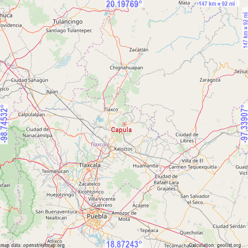
Capula GPS coordinates[2]
19° 32' 11.112" North, 98° 2' 31.884" West
| Map corner | latitude | longitude |
|---|---|---|
| Upper-left | 20.19769°, | -98.74532° |
| Center: | 19.53642°, | -98.04219° |
| Lower-right: | 18.87243°, | -97.33907° |
| Map W x H: | 147.4×147.4 km | = 91.6×91.6mi |
| max Lat: | 32.7° ⇑53.4% North |
| Capula: | 19.53642° |
| min Lat: | ⇓46.6% South 14.53588° |
| min Long | Capula | max Long |
| -117.105° | -98.04219° | -86.73105° |
| W 63.1%⇐ | ⇒36.9% E |
Elevation
Elevation of Capula is 2603 m = 8540 ft, and this is 1349.3 m = 4427 ft above average elevation for this country.
| Max E: |
3497 m = 11473 ft | 4.7% |
| Capula | 2603 m 8540 ft | |
| Avg. | 1253.7 m = 4113 ft | |
Min E: |
-1 m = -3 ft | 95.3% |
See also: Mexico elevation on elevation.city.
Geographical zone
Capula is located in North Torrid zone (between Equator and Tropic of Cancer). Distance of this Northern Tropic circle is 433.7 km =269.5 mi to North.| Distance of | km | miles | from Capula |
|---|---|---|---|
| North Pole | 7834.8 | 4868.3 | to North |
| Arctic Circle | 5228.9 | 3249.1 | to North |
| Tropic Cancer | 433.7 | 269.5 | to North |
| Equator | 2172.2 | 1349.7 | to South |


Nearby cities:
15 places around Capula: (largest is in red/bold)
• Atexcatzingo
13.3 km =8.3 mi,  235°
235°
• Calpanería Atezquilla
14.1 km =8.8 mi,  20°
20°
• Colonia José López Portillo
12 km =7.5 mi,  185°
185°
• Colonia Velazco
12.2 km =7.6 mi,  166°
166°
• Emiliano Zapata
13.4 km =8.3 mi,  79°
79°
• Guadalupe Texcalac
11.5 km =7.1 mi,  199°
199°
• José María Morelos y Pavón
5 km =3.1 mi, 192°
• Lázaro Cárdenas
6.3 km =3.9 mi,  88°
88°
• San Pedro Ecatepec
11.9 km =7.4 mi,  262°
262°
• Santa María Texcalac
13.4 km =8.3 mi, 200°
• Tecomaluca
7.6 km =4.7 mi,  343°
343°
• Tetla
12.3 km =7.6 mi,  211°
211°
• Tlaxco
11.9 km =7.4 mi,  316°
316°
• Toluca de Guadalupe
11.7 km =7.3 mi,  129°
129°
• Xaloztoc
14.3 km =8.9 mi,  181°
181°
Sources, notices
• [Note1] Compared only with cities in Mexico existing in our database
• [Src1] Map data: © OpenStreetMap contributors (CC-BY-SA)
• [Src2] Other city data from geonames.org with taken over terms of usage.
• [Src3] Geographical zone / Annual Mean Temperature by Robert A. Rohde @ Wikipedia
