Tecomaluca geodata
Tecomaluca (Tlaxcala) is a populated place; located in Mexico in America/Mexico_City (GMT-6) time zone. With population of 602 people, there are 14290 cities with bigger population in this country. Compared to other cities in Mexico, 51.8% of cities are located further ↑North; 62.9% of cities are located further ←West and 98.1% of cities have lower elevation than Tecomaluca. Note1


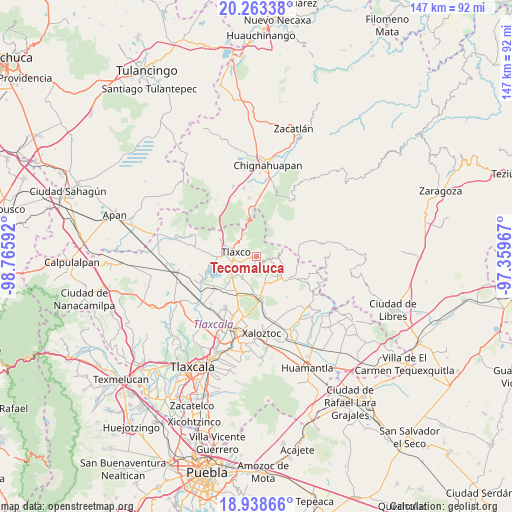
Tecomaluca GPS coordinates[2]
19° 36' 8.568" North, 98° 3' 46.044" West
| Map corner | latitude | longitude |
|---|---|---|
| Upper-left | 20.26338°, | -98.76592° |
| Center: | 19.60238°, | -98.06279° |
| Lower-right: | 18.93866°, | -97.35967° |
| Map W x H: | 147.3×147.3 km | = 91.5×91.5mi |
| max Lat: | 32.7° ⇑51.8% North |
| Tecomaluca: | 19.60238° |
| min Lat: | ⇓48.2% South 14.53588° |
| min Long | Tecomaluca | max Long |
| -117.105° | -98.06279° | -86.73105° |
| W 62.9%⇐ | ⇒37.1% E |
Elevation
Elevation of Tecomaluca is 2755 m = 9039 ft, and this is 1501.3 m = 4926 ft above average elevation for this country.
| Max E: |
3497 m = 11473 ft | 1.9% |
| Tecomaluca | 2755 m 9039 ft | |
| Avg. | 1253.7 m = 4113 ft | |
Min E: |
-1 m = -3 ft | 98.1% |
See also: Mexico elevation on elevation.city.
Geographical zone
Tecomaluca is located in North Torrid zone (between Equator and Tropic of Cancer). Distance of this Northern Tropic circle is 426.3 km =264.9 mi to North.| Distance of | km | miles | from Tecomaluca |
|---|---|---|---|
| North Pole | 7827.5 | 4863.8 | to North |
| Arctic Circle | 5221.6 | 3244.6 | to North |
| Tropic Cancer | 426.3 | 264.9 | to North |
| Equator | 2179.6 | 1354.3 | to South |


Nearby cities:
15 places around Tecomaluca: (largest is in red/bold)
• Acopinalco del Peñón
12.3 km =7.6 mi,  301°
301°
• Atexcatzingo
17.3 km =10.7 mi,  210°
210°
• Atlangatepec
17.2 km =10.7 mi,  242°
242°
• Calpanería Atezquilla
9.2 km =5.7 mi,  50°
50°
• Capula
7.6 km =4.7 mi,  163°
163°
• El Fresno
14.3 km =8.9 mi,  353°
353°
• Emiliano Zapata
16.1 km =10 mi,  107°
107°
• José María Morelos y Pavón
12.2 km =7.6 mi,  175°
175°
• Lázaro Cárdenas
11.1 km =6.9 mi,  130°
130°
• Matlahuacales Aquiles Serdán
17.8 km =11.1 mi,  3°
3°
• Rinconada
18.1 km =11.2 mi,  313°
313°
• San Antonio Matlahuacales
17.1 km =10.6 mi, 353°
• San Pedro Ecatepec
13.2 km =8.2 mi,  226°
226°
• Tlaxco
6.1 km =3.8 mi,  282°
282°
• Zumpango
17.6 km =10.9 mi,  253°
253°
Sources, notices
• [Note1] Compared only with cities in Mexico existing in our database
• [Src1] Map data: © OpenStreetMap contributors (CC-BY-SA)
• [Src2] Other city data from geonames.org with taken over terms of usage.
• [Src3] Geographical zone / Annual Mean Temperature by Robert A. Rohde @ Wikipedia
