Tlatlauquitepec geodata
Tlatlauquitepec (Guerrero) is a populated place; located in Mexico in America/Mexico_City (GMT-6) time zone. With population of 2,188 people, there are 4017 cities with bigger population in this country. Compared to other cities in Mexico, 82.6% of cities are located further ↑North; 53.2% of cities are located further ←West and 78.9% of cities have lower elevation than Tlatlauquitepec. Note1


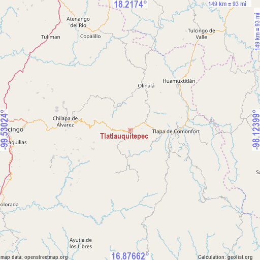
Tlatlauquitepec GPS coordinates[2]
17° 32' 53.7" North, 98° 49' 37.596" West
| Map corner | latitude | longitude |
|---|---|---|
| Upper-left | 18.2174°, | -99.53024° |
| Center: | 17.54825°, | -98.82711° |
| Lower-right: | 16.87662°, | -98.12399° |
| Map W x H: | 149.1×149.1 km | = 92.6×92.6mi |
| max Lat: | 32.7° ⇑82.6% North |
| Tlatlauquitepec: | 17.54825° |
| min Lat: | ⇓17.4% South 14.53588° |
| min Long | Tlatlauquitepec | max Long |
| -117.105° | -98.82711° | -86.73105° |
| W 53.2%⇐ | ⇒46.8% E |
Elevation
Elevation of Tlatlauquitepec is 2111 m = 6926 ft, and this is 857.3 m = 2813 ft above average elevation for this country.
| Max E: |
3497 m = 11473 ft | 21.1% |
| Tlatlauquitepec | 2111 m 6926 ft | |
| Avg. | 1253.7 m = 4113 ft | |
Min E: |
-1 m = -3 ft | 78.9% |
See also: Mexico elevation on elevation.city.
Geographical zone
Tlatlauquitepec is located in North Torrid zone (between Equator and Tropic of Cancer). Distance of this Northern Tropic circle is 654.7 km =406.8 mi to North.| Distance of | km | miles | from Tlatlauquitepec |
|---|---|---|---|
| North Pole | 8055.9 | 5005.7 | to North |
| Arctic Circle | 5450 | 3386.5 | to North |
| Tropic Cancer | 654.7 | 406.8 | to North |
| Equator | 1951.2 | 1212.4 | to South |


Nearby cities:
15 places around Tlatlauquitepec: (largest is in red/bold)
• Alpuyecancingo de las Montañas
13.9 km =8.6 mi,  349°
349°
• Aquilpa
12.6 km =7.8 mi,  92°
92°
• Atlixtac
11.5 km =7.1 mi,  278°
278°
• Ayotzinapa
6.8 km =4.2 mi,  82°
82°
• Cacahuatepec
6.9 km =4.3 mi,  111°
111°
• Chiepetepec
10.1 km =6.3 mi, 78°
• Copanatoyac
15.3 km =9.5 mi,  128°
128°
• Huitzacotla
8.4 km =5.2 mi, 278°
• Pochutla
14.4 km =8.9 mi,  328°
328°
• San Juan Bautista Coapala
12 km =7.5 mi,  186°
186°
• San Pedro Huitzapula Norte (Huitzapula Norte)
13.7 km =8.5 mi,  170°
170°
• San Pedro Petlacala
16.5 km =10.3 mi, 76°
• Tlalquetzalapa
12.6 km =7.8 mi,  115°
115°
• Xalpitzáhuac
14.7 km =9.1 mi,  201°
201°
• Zapotitlán Tablas
14.7 km =9.1 mi,  160°
160°
Sources, notices
• [Note1] Compared only with cities in Mexico existing in our database
• [Src1] Map data: © OpenStreetMap contributors (CC-BY-SA)
• [Src2] Other city data from geonames.org with taken over terms of usage.
• [Src3] Geographical zone / Annual Mean Temperature by Robert A. Rohde @ Wikipedia
