Huitzacotla geodata
Huitzacotla (Guerrero) is a populated place; located in Mexico in America/Mexico_City (GMT-6) time zone. With population of 512 people, there are 16417 cities with bigger population in this country. Compared to other cities in Mexico, 82.5% of cities are located further ↑North; 51.8% of cities are located further ←West and 70.2% of cities have lower elevation than Huitzacotla. Note1


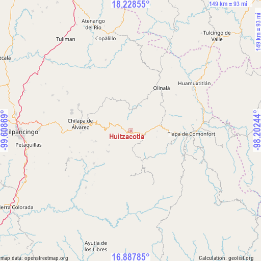
Huitzacotla GPS coordinates[2]
17° 33' 33.984" North, 98° 54' 20.016" West
| Map corner | latitude | longitude |
|---|---|---|
| Upper-left | 18.22855°, | -99.60869° |
| Center: | 17.55944°, | -98.90556° |
| Lower-right: | 16.88785°, | -98.20244° |
| Map W x H: | 149.1×149.1 km | = 92.6×92.6mi |
| max Lat: | 32.7° ⇑82.5% North |
| Huitzacotla: | 17.55944° |
| min Lat: | ⇓17.5% South 14.53588° |
| min Long | Huitzacotla | max Long |
| -117.105° | -98.90556° | -86.73105° |
| W 51.8%⇐ | ⇒48.2% E |
Elevation
Elevation of Huitzacotla is 1929 m = 6329 ft, and this is 675.3 m = 2216 ft above average elevation for this country.
| Max E: |
3497 m = 11473 ft | 29.8% |
| Huitzacotla | 1929 m 6329 ft | |
| Avg. | 1253.7 m = 4113 ft | |
Min E: |
-1 m = -3 ft | 70.2% |
See also: Mexico elevation on elevation.city.
Geographical zone
Huitzacotla is located in North Torrid zone (between Equator and Tropic of Cancer). Distance of this Northern Tropic circle is 653.5 km =406.1 mi to North.| Distance of | km | miles | from Huitzacotla |
|---|---|---|---|
| North Pole | 8054.6 | 5004.9 | to North |
| Arctic Circle | 5448.7 | 3385.7 | to North |
| Tropic Cancer | 653.5 | 406.1 | to North |
| Equator | 1952.4 | 1213.2 | to South |


Nearby cities:
15 places around Huitzacotla: (largest is in red/bold)
• Ahuixtla
14.2 km =8.8 mi,  256°
256°
• Alpuyecancingo de las Montañas
13.6 km =8.5 mi,  24°
24°
• Apanguito
15 km =9.3 mi,  213°
213°
• Atlixtac
3.1 km =1.9 mi,  277°
277°
• Ayotzinapa
15.1 km =9.4 mi,  91°
91°
• Cacahuatepec
15.2 km =9.4 mi,  104°
104°
• Mazazontecomac
13.5 km =8.4 mi, 211°
• Petatlán
9.2 km =5.7 mi, 284°
• Pochutla
11.1 km =6.9 mi,  4°
4°
• San Juan Bautista Coapala
14.9 km =9.3 mi,  151°
151°
• Tepozonalco
13.3 km =8.3 mi, 276°
• Tlachimaltepec
14.1 km =8.8 mi,  233°
233°
• Tlatlauquitepec
8.4 km =5.2 mi, 98°
• Tomactilicán
14.9 km =9.3 mi,  221°
221°
• Xalpitzáhuac
15.2 km =9.4 mi,  168°
168°
Sources, notices
• [Note1] Compared only with cities in Mexico existing in our database
• [Src1] Map data: © OpenStreetMap contributors (CC-BY-SA)
• [Src2] Other city data from geonames.org with taken over terms of usage.
• [Src3] Geographical zone / Annual Mean Temperature by Robert A. Rohde @ Wikipedia
