Cuetzalingo geodata
Cuetzalingo (Puebla) is a populated place; located in Mexico in America/Mexico_City (GMT-6) time zone. With population of 639 people, there are 13559 cities with bigger population in this country. Compared to other cities in Mexico, 58.5% of cities are located further ↓South; 64.5% of cities are located further ←West and 56.3% of cities have higher elevation than Cuetzalingo. Note1


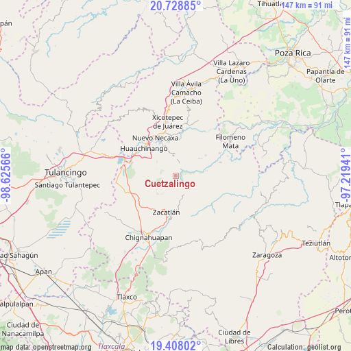
Cuetzalingo GPS coordinates[2]
20° 4' 11.388" North, 97° 55' 21.108" West
| Map corner | latitude | longitude |
|---|---|---|
| Upper-left | 20.72885°, | -98.62566° |
| Center: | 20.06983°, | -97.92253° |
| Lower-right: | 19.40802°, | -97.21941° |
| Map W x H: | 146.9×146.9 km | = 91.3×91.3mi |
| max Lat: | 32.7° ⇑41.5% North |
| Cuetzalingo: | 20.06983° |
| min Lat: | ⇓58.5% South 14.53588° |
| min Long | Cuetzalingo | max Long |
| -117.105° | -97.92253° | -86.73105° |
| W 64.5%⇐ | ⇒35.5% E |
Elevation
Elevation of Cuetzalingo is 1148 m = 3766 ft, and this is 105.7 m = 347 ft below average elevation for this country.
| Max E: |
3497 m = 11473 ft | 56.3% |
| Avg. | 1253.7 m = 4113 ft | |
| Cuetzalingo | 1148 m = 3766 ft | |
Min E: |
-1 m = -3 ft | 43.7% |
See also: Mexico elevation on elevation.city.
Geographical zone
Cuetzalingo is located in North Torrid zone (between Equator and Tropic of Cancer). Distance of this Northern Tropic circle is 374.4 km =232.6 mi to North.| Distance of | km | miles | from Cuetzalingo |
|---|---|---|---|
| North Pole | 7775.5 | 4831.5 | to North |
| Arctic Circle | 5169.6 | 3212.2 | to North |
| Tropic Cancer | 374.4 | 232.6 | to North |
| Equator | 2231.6 | 1386.7 | to South |


Nearby cities:
15 places around Cuetzalingo: (largest is in red/bold)
• Chiconcuautla
3.3 km =2.1 mi,  328°
328°
• Cutzontipa
5 km =3.1 mi,  22°
22°
• Jilotzingo
4.6 km =2.9 mi,  153°
153°
• Palzoquitla
7.5 km =4.7 mi,  312°
312°
• San Cristóbal Xochimilpa
1.6 km =1 mi,  103°
103°
• San Marcos Eloxochitlán
7.2 km =4.5 mi,  133°
133°
• Tepexco
5.9 km =3.7 mi,  219°
219°
• Tlacotepec (San Mateo)
7.7 km =4.8 mi, 97°
• Tlaltenango
6.6 km =4.1 mi,  322°
322°
• Tlaola
7.6 km =4.7 mi,  359°
359°
• Tlaxco (Santiago Tlaxco)
4.4 km =2.7 mi,  252°
252°
• Toxtla
2.6 km =1.6 mi,  261°
261°
• Xochicuautla
3.9 km =2.4 mi,  117°
117°
• Xoxonacatla
7.2 km =4.5 mi,  195°
195°
• Zempoala
8.2 km =5.1 mi,  283°
283°
Sources, notices
• [Note1] Compared only with cities in Mexico existing in our database
• [Src1] Map data: © OpenStreetMap contributors (CC-BY-SA)
• [Src2] Other city data from geonames.org with taken over terms of usage.
• [Src3] Geographical zone / Annual Mean Temperature by Robert A. Rohde @ Wikipedia
