San Cristóbal Xochimilpa geodata
San Cristóbal Xochimilpa (Puebla) is a populated place; located in Mexico in America/Mexico_City (GMT-6) time zone. With population of 1,077 people, there are 8093 cities with bigger population in this country. Compared to other cities in Mexico, 58.5% of cities are located further ↓South; 64.8% of cities are located further ←West and 58.4% of cities have higher elevation than San Cristóbal Xochimilpa. Note1
Current local time in San Cristóbal Xochimilpa:
08:29 AM, WednesdayDifference from your time zone: hours


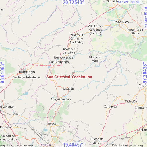
San Cristóbal Xochimilpa GPS coordinates[2]
20° 3' 59.004" North, 97° 54' 27" West
| Map corner | latitude | longitude |
|---|---|---|
| Upper-left | 20.72543°, | -98.61063° |
| Center: | 20.06639°, | -97.9075° |
| Lower-right: | 19.40457°, | -97.20438° |
| Map W x H: | 146.9×146.9 km | = 91.3×91.3mi |
| max Lat: | 32.7° ⇑41.5% North |
| San Cristóbal Xochimilpa: | 20.06639° |
| min Lat: | ⇓58.5% South 14.53588° |
| min Long | San Cristóbal | max Long |
| -117.105° | -97.9075° | -86.73105° |
| W 64.8%⇐ | ⇒35.2% E |
Elevation
Elevation of San Cristóbal Xochimilpa is 1084 m = 3556 ft, and this is 169.7 m = 557 ft below average elevation for this country.
| Max E: |
3497 m = 11473 ft | 58.4% |
| Avg. | 1253.7 m = 4113 ft | |
| San Cristóbal Xochimilpa | 1084 m = 3556 ft | |
Min E: |
-1 m = -3 ft | 41.6% |
See also: Mexico elevation on elevation.city.
Geographical zone
San Cristóbal Xochimilpa is located in North Torrid zone (between Equator and Tropic of Cancer). Distance of this Northern Tropic circle is 374.7 km =232.8 mi to North.| Distance of | km | miles | from San Cristóbal Xochimilpa |
|---|---|---|---|
| North Pole | 7775.9 | 4831.7 | to North |
| Arctic Circle | 5170 | 3212.5 | to North |
| Tropic Cancer | 374.7 | 232.8 | to North |
| Equator | 2231.2 | 1386.4 | to South |


Nearby cities:
15 places around San Cristóbal Xochimilpa: (largest is in red/bold)
• Chiconcuautla
4.6 km =2.9 mi,  314°
314°
• Cuetzalingo
1.6 km =1 mi,  283°
283°
• Cutzontipa
5 km =3.1 mi,  3°
3°
• Jilotzingo
3.8 km =2.4 mi,  172°
172°
• La Cumbre
8.2 km =5.1 mi,  43°
43°
• San Jerónimo Coaltepec
8.2 km =5.1 mi,  148°
148°
• San Marcos Eloxochitlán
5.9 km =3.7 mi,  140°
140°
• Tepexco
6.7 km =4.2 mi,  231°
231°
• Tlacotepec (San Mateo)
6.1 km =3.8 mi,  96°
96°
• Tlaltenango
8 km =5 mi,  315°
315°
• Tlaxco (Santiago Tlaxco)
5.8 km =3.6 mi,  260°
260°
• Tonalapa (Santa Bárbara)
6.9 km =4.3 mi,  115°
115°
• Toxtla
4.2 km =2.6 mi,  269°
269°
• Xochicuautla
2.4 km =1.5 mi,  126°
126°
• Xoxonacatla
7.4 km =4.6 mi,  207°
207°
Sources, notices
• [Note1] Compared only with cities in Mexico existing in our database
• [Src1] Map data: © OpenStreetMap contributors (CC-BY-SA)
• [Src2] Other city data from geonames.org with taken over terms of usage.
• [Src3] Geographical zone / Annual Mean Temperature by Robert A. Rohde @ Wikipedia
