Tilzapotla geodata
Tilzapotla (Morelos) is a populated place; located in Mexico in America/Mexico_City (GMT-6) time zone. With population of 4,789 people, there are 1931 cities with bigger population in this country. Compared to other cities in Mexico, 72.8% of cities are located further ↑North; 53.9% of cities are located further →East and 59.8% of cities have higher elevation than Tilzapotla. Note1


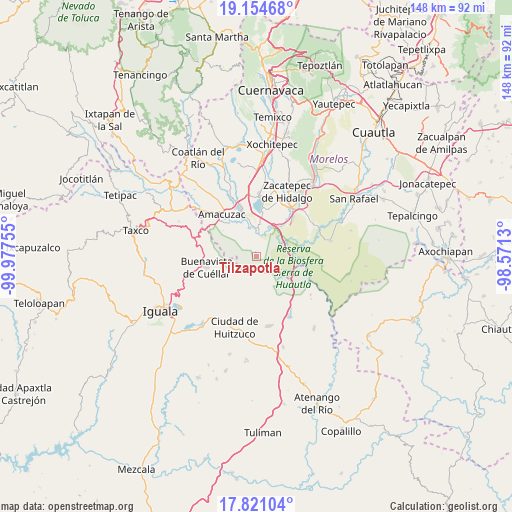
Tilzapotla GPS coordinates[2]
18° 29' 20.976" North, 99° 16' 27.912" West
| Map corner | latitude | longitude |
|---|---|---|
| Upper-left | 19.15468°, | -99.97755° |
| Center: | 18.48916°, | -99.27442° |
| Lower-right: | 17.82104°, | -98.5713° |
| Map W x H: | 148.3×148.3 km | = 92.1×92.1mi |
| max Lat: | 32.7° ⇑72.8% North |
| Tilzapotla: | 18.48916° |
| min Lat: | ⇓27.2% South 14.53588° |
| min Long | Tilzapotla | max Long |
| -117.105° | -99.27442° | -86.73105° |
| W 46.1%⇐ | ⇒53.9% E |
Elevation
Elevation of Tilzapotla is 1016 m = 3333 ft, and this is 237.7 m = 780 ft below average elevation for this country.
| Max E: |
3497 m = 11473 ft | 59.8% |
| Avg. | 1253.7 m = 4113 ft | |
| Tilzapotla | 1016 m = 3333 ft | |
Min E: |
-1 m = -3 ft | 40.2% |
See also: Mexico elevation on elevation.city.
Geographical zone
Tilzapotla is located in North Torrid zone (between Equator and Tropic of Cancer). Distance of this Northern Tropic circle is 550.1 km =341.8 mi to North.| Distance of | km | miles | from Tilzapotla |
|---|---|---|---|
| North Pole | 7951.3 | 4940.7 | to North |
| Arctic Circle | 5345.4 | 3321.5 | to North |
| Tropic Cancer | 550.1 | 341.8 | to North |
| Equator | 2055.8 | 1277.4 | to South |


Nearby cities:
15 places around Tilzapotla: (largest is in red/bold)
• Buenavista de Cuéllar
14.5 km =9 mi,  256°
256°
• Cajones
12.2 km =7.6 mi,  321°
321°
• Casahuatlán
15.4 km =9.6 mi,  307°
307°
• Coahuixtla
13.8 km =8.6 mi, 313°
• El Coco
12 km =7.5 mi,  340°
340°
• El Estudiante
10.1 km =6.3 mi,  346°
346°
• Higuerón
13.9 km =8.6 mi,  45°
45°
• Jicarero
15 km =9.3 mi,  21°
21°
• Miahuatlán (El Cuiji)
14 km =8.7 mi, 323°
• Puente de Ixtla
14.7 km =9.1 mi, 341°
• Rancho Nuevo
12 km =7.5 mi,  304°
304°
• Tehuixtla
7.8 km =4.8 mi,  2°
2°
• Tequesquitengo
13.6 km =8.5 mi,  6°
6°
• Tlatenchi
15.1 km =9.4 mi,  37°
37°
• Unidad Habitacional José María Morelos y Pavón
15.7 km =9.8 mi, 21°
Sources, notices
• [Note1] Compared only with cities in Mexico existing in our database
• [Src1] Map data: © OpenStreetMap contributors (CC-BY-SA)
• [Src2] Other city data from geonames.org with taken over terms of usage.
• [Src3] Geographical zone / Annual Mean Temperature by Robert A. Rohde @ Wikipedia
