El Estudiante geodata
El Estudiante (Morelos) is a populated place; located in Mexico in America/Mexico_City (GMT-6) time zone. With population of 1,553 people, there are 5553 cities with bigger population in this country. Compared to other cities in Mexico, 71.7% of cities are located further ↑North; 54.2% of cities are located further →East and 62.2% of cities have higher elevation than El Estudiante. Note1


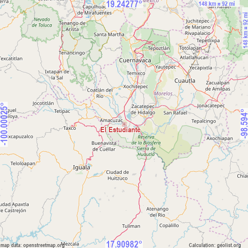
El Estudiante GPS coordinates[2]
18° 34' 39.36" North, 99° 17' 49.632" West
| Map corner | latitude | longitude |
|---|---|---|
| Upper-left | 19.24277°, | -100.00025° |
| Center: | 18.5776°, | -99.29712° |
| Lower-right: | 17.90982°, | -98.594° |
| Map W x H: | 148.2×148.2 km | = 92.1×92.1mi |
| max Lat: | 32.7° ⇑71.7% North |
| El Estudiante: | 18.5776° |
| min Lat: | ⇓28.3% South 14.53588° |
| min Long | El Estudiante | max Long |
| -117.105° | -99.29712° | -86.73105° |
| W 45.8%⇐ | ⇒54.2% E |
Elevation
Elevation of El Estudiante is 871 m = 2858 ft, and this is 382.7 m = 1256 ft below average elevation for this country.
| Max E: |
3497 m = 11473 ft | 62.2% |
| Avg. | 1253.7 m = 4113 ft | |
| El Estudiante | 871 m = 2858 ft | |
Min E: |
-1 m = -3 ft | 37.8% |
See also: Mexico elevation on elevation.city.
Geographical zone
El Estudiante is located in North Torrid zone (between Equator and Tropic of Cancer). Distance of this Northern Tropic circle is 540.3 km =335.7 mi to North.| Distance of | km | miles | from El Estudiante |
|---|---|---|---|
| North Pole | 7941.4 | 4934.6 | to North |
| Arctic Circle | 5335.5 | 3315.3 | to North |
| Tropic Cancer | 540.3 | 335.7 | to North |
| Equator | 2065.6 | 1283.5 | to South |


Nearby cities:
15 places around El Estudiante: (largest is in red/bold)
• 24 de Febrero
7.4 km =4.6 mi,  333°
333°
• Amacuzac
8 km =5 mi,  287°
287°
• Cajones
5.2 km =3.2 mi,  266°
266°
• Casahuatlán
9.9 km =6.2 mi, 266°
• Coahuixtla
7.7 km =4.8 mi, 267°
• El Coco
2.2 km =1.4 mi,  310°
310°
• Jicarero
8.8 km =5.5 mi,  61°
61°
• Miahuatlán (El Cuiji)
6.1 km =3.8 mi,  283°
283°
• Puente de Ixtla
4.7 km =2.9 mi, 331°
• Rancho Nuevo
8 km =5 mi,  248°
248°
• San Gabriel las Palmas
6.6 km =4.1 mi, 307°
• San José Vista Hermosa
9.1 km =5.7 mi,  20°
20°
• Tehuixtla
3.4 km =2.1 mi,  126°
126°
• Tequesquitengo
5.4 km =3.4 mi,  46°
46°
• Unidad Habitacional José María Morelos y Pavón
9.5 km =5.9 mi, 60°
Sources, notices
• [Note1] Compared only with cities in Mexico existing in our database
• [Src1] Map data: © OpenStreetMap contributors (CC-BY-SA)
• [Src2] Other city data from geonames.org with taken over terms of usage.
• [Src3] Geographical zone / Annual Mean Temperature by Robert A. Rohde @ Wikipedia
