Puente de Ixtla geodata
Puente de Ixtla (Morelos) is a populated place; located in Mexico in America/Mexico_City (GMT-6) time zone. With population of 21,098 people, there are 482 cities with bigger population in this country. Compared to other cities in Mexico, 71.3% of cities are located further ↑North; 54.4% of cities are located further →East and 61.4% of cities have higher elevation than Puente de Ixtla. Note1


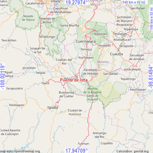
Puente de Ixtla GPS coordinates[2]
18° 36' 52.992" North, 99° 19' 5.016" West
| Map corner | latitude | longitude |
|---|---|---|
| Upper-left | 19.27974°, | -100.02119° |
| Center: | 18.61472°, | -99.31806° |
| Lower-right: | 17.94709°, | -98.61494° |
| Map W x H: | 148.2×148.2 km | = 92.1×92.1mi |
| max Lat: | 32.7° ⇑71.3% North |
| Puente de Ixtla: | 18.61472° |
| min Lat: | ⇓28.7% South 14.53588° |
| min Long | Puente de Ixtla | max Long |
| -117.105° | -99.31806° | -86.73105° |
| W 45.6%⇐ | ⇒54.4% E |
Elevation
Elevation of Puente de Ixtla is 911 m = 2989 ft, and this is 342.7 m = 1124 ft below average elevation for this country.
| Max E: |
3497 m = 11473 ft | 61.4% |
| Avg. | 1253.7 m = 4113 ft | |
| Puente de Ixtla | 911 m = 2989 ft | |
Min E: |
-1 m = -3 ft | 38.6% |
See also: Mexico elevation on elevation.city.
Geographical zone
Puente de Ixtla is located in North Torrid zone (between Equator and Tropic of Cancer). Distance of this Northern Tropic circle is 536.2 km =333.2 mi to North.| Distance of | km | miles | from Puente de Ixtla |
|---|---|---|---|
| North Pole | 7937.3 | 4932 | to North |
| Arctic Circle | 5331.4 | 3312.8 | to North |
| Tropic Cancer | 536.2 | 333.2 | to North |
| Equator | 2069.8 | 1286.1 | to South |


Nearby cities:
15 places around Puente de Ixtla: (largest is in red/bold)
• 24 de Febrero
2.7 km =1.7 mi,  337°
337°
• Ahuehuetzingo
7.4 km =4.6 mi,  8°
8°
• Amacuzac
5.7 km =3.5 mi,  251°
251°
• Cajones
5.3 km =3.3 mi,  213°
213°
• Casahuatlán
9 km =5.6 mi,  238°
238°
• Coahuixtla
7.1 km =4.4 mi,  230°
230°
• Cuauchichinola
8.2 km =5.1 mi,  311°
311°
• El Coco
2.7 km =1.7 mi,  168°
168°
• El Estudiante
4.7 km =2.9 mi,  151°
151°
• Miahuatlán (El Cuiji)
4.6 km =2.9 mi, 233°
• Rancho Nuevo
8.8 km =5.5 mi,  216°
216°
• San Gabriel las Palmas
3 km =1.9 mi,  268°
268°
• San José Vista Hermosa
7 km =4.3 mi,  51°
51°
• Tehuixtla
7.9 km =4.9 mi,  141°
141°
• Tequesquitengo
6.1 km =3.8 mi,  93°
93°
Sources, notices
• [Note1] Compared only with cities in Mexico existing in our database
• [Src1] Map data: © OpenStreetMap contributors (CC-BY-SA)
• [Src2] Other city data from geonames.org with taken over terms of usage.
• [Src3] Geographical zone / Annual Mean Temperature by Robert A. Rohde @ Wikipedia
