El Coco geodata
El Coco (Morelos) is a populated place; located in Mexico in America/Mexico_City (GMT-6) time zone. With population of 621 people, there are 13905 cities with bigger population in this country. Compared to other cities in Mexico, 71.6% of cities are located further ↑North; 54.3% of cities are located further →East and 61.8% of cities have higher elevation than El Coco. Note1


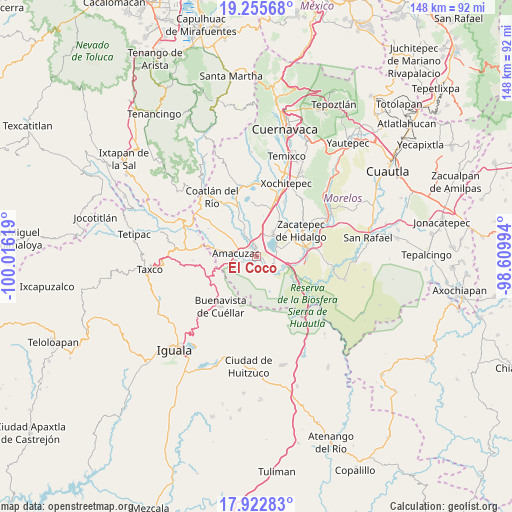
El Coco GPS coordinates[2]
18° 35' 26.016" North, 99° 18' 47.016" West
| Map corner | latitude | longitude |
|---|---|---|
| Upper-left | 19.25568°, | -100.01619° |
| Center: | 18.59056°, | -99.31306° |
| Lower-right: | 17.92283°, | -98.60994° |
| Map W x H: | 148.2×148.2 km | = 92.1×92.1mi |
| max Lat: | 32.7° ⇑71.6% North |
| El Coco: | 18.59056° |
| min Lat: | ⇓28.4% South 14.53588° |
| min Long | El Coco | max Long |
| -117.105° | -99.31306° | -86.73105° |
| W 45.7%⇐ | ⇒54.3% E |
Elevation
Elevation of El Coco is 891 m = 2923 ft, and this is 362.7 m = 1190 ft below average elevation for this country.
| Max E: |
3497 m = 11473 ft | 61.8% |
| Avg. | 1253.7 m = 4113 ft | |
| El Coco | 891 m = 2923 ft | |
Min E: |
-1 m = -3 ft | 38.2% |
See also: Mexico elevation on elevation.city.
Geographical zone
El Coco is located in North Torrid zone (between Equator and Tropic of Cancer). Distance of this Northern Tropic circle is 538.8 km =334.8 mi to North.| Distance of | km | miles | from El Coco |
|---|---|---|---|
| North Pole | 7940 | 4933.7 | to North |
| Arctic Circle | 5334.1 | 3314.5 | to North |
| Tropic Cancer | 538.8 | 334.8 | to North |
| Equator | 2067.1 | 1284.4 | to South |


Nearby cities:
15 places around El Coco: (largest is in red/bold)
• 24 de Febrero
5.4 km =3.4 mi,  343°
343°
• Ahuehuetzingo
10 km =6.2 mi,  2°
2°
• Amacuzac
6 km =3.7 mi,  278°
278°
• Cajones
3.9 km =2.4 mi,  243°
243°
• Casahuatlán
8.4 km =5.2 mi,  256°
256°
• Coahuixtla
6.3 km =3.9 mi,  253°
253°
• El Estudiante
2.2 km =1.4 mi,  130°
130°
• Jicarero
9.8 km =6.1 mi,  74°
74°
• Miahuatlán (El Cuiji)
4.2 km =2.6 mi,  269°
269°
• Puente de Ixtla
2.7 km =1.7 mi,  348°
348°
• Rancho Nuevo
7.3 km =4.5 mi,  232°
232°
• San Gabriel las Palmas
4.4 km =2.7 mi,  306°
306°
• San José Vista Hermosa
8.6 km =5.3 mi,  34°
34°
• Tehuixtla
5.6 km =3.5 mi, 128°
• Tequesquitengo
6 km =3.7 mi, 67°
Sources, notices
• [Note1] Compared only with cities in Mexico existing in our database
• [Src1] Map data: © OpenStreetMap contributors (CC-BY-SA)
• [Src2] Other city data from geonames.org with taken over terms of usage.
• [Src3] Geographical zone / Annual Mean Temperature by Robert A. Rohde @ Wikipedia
