Tenejapa geodata
Tenejapa (Chiapas) is a seat of a second-order administrative division; located in Mexico in America/Mexico_City (GMT-6) time zone. With population of 1,998 people, there are 4356 cities with bigger population in this country. Compared to other cities in Mexico, 91.4% of cities are located further ↑North; 91.8% of cities are located further ←West and 74.1% of cities have lower elevation than Tenejapa. Note1


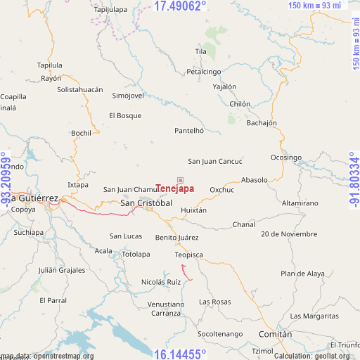
Tenejapa GPS coordinates[2]
16° 49' 7.608" North, 92° 30' 23.256" West
| Map corner | latitude | longitude |
|---|---|---|
| Upper-left | 17.49062°, | -93.20959° |
| Center: | 16.81878°, | -92.50646° |
| Lower-right: | 16.14455°, | -91.80334° |
| Map W x H: | 149.7×149.7 km | = 93×93mi |
| max Lat: | 32.7° ⇑91.4% North |
| Tenejapa: | 16.81878° |
| min Lat: | ⇓8.6% South 14.53588° |
| min Long | Tenejapa | max Long |
| -117.105° | -92.50646° | -86.73105° |
| W 91.8%⇐ | ⇒8.2% E |
Elevation
Elevation of Tenejapa is 2013 m = 6604 ft, and this is 759.3 m = 2491 ft above average elevation for this country.
| Max E: |
3497 m = 11473 ft | 25.9% |
| Tenejapa | 2013 m 6604 ft | |
| Avg. | 1253.7 m = 4113 ft | |
Min E: |
-1 m = -3 ft | 74.1% |
See also: Mexico elevation on elevation.city.
Geographical zone
Tenejapa is located in North Torrid zone (between Equator and Tropic of Cancer). Distance of this Northern Tropic circle is 735.8 km =457.2 mi to North.| Distance of | km | miles | from Tenejapa |
|---|---|---|---|
| North Pole | 8137 | 5056.1 | to North |
| Arctic Circle | 5531.1 | 3436.9 | to North |
| Tropic Cancer | 735.8 | 457.2 | to North |
| Equator | 1870.1 | 1162 | to South |


Nearby cities:
15 places around Tenejapa: (largest is in red/bold)
• Cañada Grande
1.7 km =1.1 mi,  267°
267°
• Chacoma
6.6 km =4.1 mi,  14°
14°
• Cruzchén
3.9 km =2.4 mi,  72°
72°
• El Retiro
5.5 km =3.4 mi,  112°
112°
• Jerusalén
4.7 km =2.9 mi,  58°
58°
• Kotolte
5.1 km =3.2 mi, 268°
• Las Ollas
6.4 km =4 mi,  229°
229°
• Matzam
4.6 km =2.9 mi,  136°
136°
• Ococh
4 km =2.5 mi, 57°
• Pajaltón
3.1 km =1.9 mi,  303°
303°
• Pajaltón Bajo
5.3 km =3.3 mi,  294°
294°
• Shishintonil
4 km =2.5 mi,  35°
35°
• Tz'Aquiviljok
6.4 km =4 mi,  50°
50°
• Tzajalchén
5.5 km =3.4 mi, 62°
• Yashanal
5.9 km =3.7 mi,  79°
79°
Sources, notices
• [Note1] Compared only with cities in Mexico existing in our database
• [Src1] Map data: © OpenStreetMap contributors (CC-BY-SA)
• [Src2] Other city data from geonames.org with taken over terms of usage.
• [Src3] Geographical zone / Annual Mean Temperature by Robert A. Rohde @ Wikipedia
