Matzam geodata
Matzam (Chiapas) is a populated place; located in Mexico in America/Mexico_City (GMT-6) time zone. With population of 1,599 people, there are 5406 cities with bigger population in this country. Compared to other cities in Mexico, 91.9% of cities are located further ↑North; 92.1% of cities are located further ←West and 89.3% of cities have lower elevation than Matzam. Note1


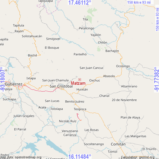
Matzam GPS coordinates[2]
16° 47' 21.012" North, 92° 28' 36.984" West
| Map corner | latitude | longitude |
|---|---|---|
| Upper-left | 17.46112°, | -93.18007° |
| Center: | 16.78917°, | -92.47694° |
| Lower-right: | 16.11484°, | -91.77382° |
| Map W x H: | 149.7×149.7 km | = 93×93mi |
| max Lat: | 32.7° ⇑91.9% North |
| Matzam: | 16.78917° |
| min Lat: | ⇓8.1% South 14.53588° |
| min Long | Matzam | max Long |
| -117.105° | -92.47694° | -86.73105° |
| W 92.1%⇐ | ⇒7.9% E |
Elevation
Elevation of Matzam is 2384 m = 7822 ft, and this is 1130.3 m = 3708 ft above average elevation for this country.
| Max E: |
3497 m = 11473 ft | 10.7% |
| Matzam | 2384 m 7822 ft | |
| Avg. | 1253.7 m = 4113 ft | |
Min E: |
-1 m = -3 ft | 89.3% |
See also: Mexico elevation on elevation.city.
Geographical zone
Matzam is located in North Torrid zone (between Equator and Tropic of Cancer). Distance of this Northern Tropic circle is 739.1 km =459.3 mi to North.| Distance of | km | miles | from Matzam |
|---|---|---|---|
| North Pole | 8140.3 | 5058.1 | to North |
| Arctic Circle | 5534.4 | 3438.9 | to North |
| Tropic Cancer | 739.1 | 459.3 | to North |
| Equator | 1866.8 | 1160 | to South |


Nearby cities:
15 places around Matzam: (largest is in red/bold)
• Cañada Grande
5.8 km =3.6 mi,  303°
303°
• Cruzchén
4.5 km =2.8 mi,  7°
7°
• El Retiro
2.3 km =1.4 mi,  58°
58°
• Jerusalén
5.8 km =3.6 mi, 9°
• Jocosic
3.5 km =2.2 mi,  142°
142°
• La Candelaria
7 km =4.3 mi,  222°
222°
• Ococh
5.4 km =3.4 mi,  1°
1°
• Oquem
7.2 km =4.5 mi,  181°
181°
• San Pedro la Tejería
7.6 km =4.7 mi,  207°
207°
• Shishintonil
6.6 km =4.1 mi,  353°
353°
• Tenejapa
4.6 km =2.9 mi,  316°
316°
• Tz'Aquiviljok
7.6 km =4.7 mi, 14°
• Tzajalchén
6.1 km =3.8 mi,  17°
17°
• Yashanal
5.2 km =3.2 mi,  31°
31°
• Yoshib
7 km =4.3 mi, 27°
Sources, notices
• [Note1] Compared only with cities in Mexico existing in our database
• [Src1] Map data: © OpenStreetMap contributors (CC-BY-SA)
• [Src2] Other city data from geonames.org with taken over terms of usage.
• [Src3] Geographical zone / Annual Mean Temperature by Robert A. Rohde @ Wikipedia
