Las Ollas geodata
Las Ollas (Chiapas) is a populated place; located in Mexico in America/Mexico_City (GMT-6) time zone. With population of 1,165 people, there are 7447 cities with bigger population in this country. Compared to other cities in Mexico, 92% of cities are located further ↑North; 91.4% of cities are located further ←West and 92.3% of cities have lower elevation than Las Ollas. Note1


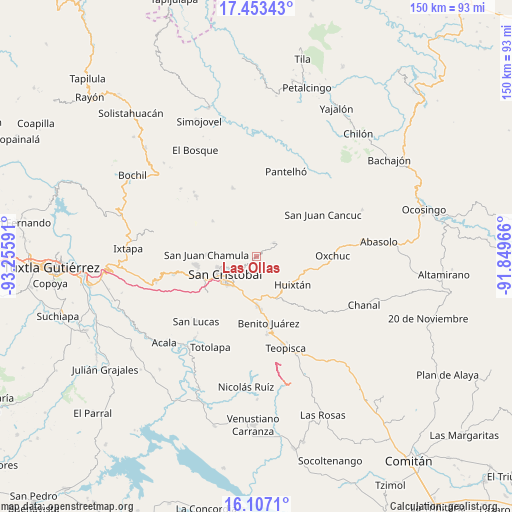
Las Ollas GPS coordinates[2]
16° 46' 53.256" North, 92° 33' 10.008" West
| Map corner | latitude | longitude |
|---|---|---|
| Upper-left | 17.45343°, | -93.25591° |
| Center: | 16.78146°, | -92.55278° |
| Lower-right: | 16.1071°, | -91.84966° |
| Map W x H: | 149.7×149.7 km | = 93×93mi |
| max Lat: | 32.7° ⇑92% North |
| Las Ollas: | 16.78146° |
| min Lat: | ⇓8% South 14.53588° |
| min Long | Las Ollas | max Long |
| -117.105° | -92.55278° | -86.73105° |
| W 91.4%⇐ | ⇒8.6% E |
Elevation
Elevation of Las Ollas is 2500 m = 8202 ft, and this is 1246.3 m = 4089 ft above average elevation for this country.
| Max E: |
3497 m = 11473 ft | 7.7% |
| Las Ollas | 2500 m 8202 ft | |
| Avg. | 1253.7 m = 4113 ft | |
Min E: |
-1 m = -3 ft | 92.3% |
See also: Mexico elevation on elevation.city.
Geographical zone
Las Ollas is located in North Torrid zone (between Equator and Tropic of Cancer). Distance of this Northern Tropic circle is 740 km =459.8 mi to North.| Distance of | km | miles | from Las Ollas |
|---|---|---|---|
| North Pole | 8141.1 | 5058.6 | to North |
| Arctic Circle | 5535.3 | 3439.5 | to North |
| Tropic Cancer | 740 | 459.8 | to North |
| Equator | 1865.9 | 1159.4 | to South |


Nearby cities:
15 places around Las Ollas: (largest is in red/bold)
• Agua de Pajarito
5.3 km =3.3 mi,  196°
196°
• Cañada Grande
5.2 km =3.2 mi,  38°
38°
• Chilimjoveltic
2.9 km =1.8 mi,  283°
283°
• Cruztón
3.6 km =2.2 mi,  231°
231°
• El Crucero
2.6 km =1.6 mi,  325°
325°
• El Pinar
6.2 km =3.9 mi,  245°
245°
• Kotolte
4 km =2.5 mi,  357°
357°
• La Candelaria
5.4 km =3.4 mi,  142°
142°
• Pajaltón
6.3 km =3.9 mi,  21°
21°
• Pajaltón Alto
5.7 km =3.5 mi,  338°
338°
• Pajaltón Bajo
6.4 km =4 mi,  0°
0°
• Romerillo
2.4 km =1.5 mi,  221°
221°
• Sactzu
6.2 km =3.9 mi,  285°
285°
• Tenejapa
6.4 km =4 mi,  49°
49°
• Tzontehuitz
6.4 km =4 mi, 333°
Sources, notices
• [Note1] Compared only with cities in Mexico existing in our database
• [Src1] Map data: © OpenStreetMap contributors (CC-BY-SA)
• [Src2] Other city data from geonames.org with taken over terms of usage.
• [Src3] Geographical zone / Annual Mean Temperature by Robert A. Rohde @ Wikipedia
