Kotolte geodata
Kotolte (Chiapas) is a populated place; located in Mexico in America/Mexico_City (GMT-6) time zone. With population of 888 people, there are 9821 cities with bigger population in this country. Compared to other cities in Mexico, 91.5% of cities are located further ↑North; 91.4% of cities are located further ←West and 90.5% of cities have lower elevation than Kotolte. Note1


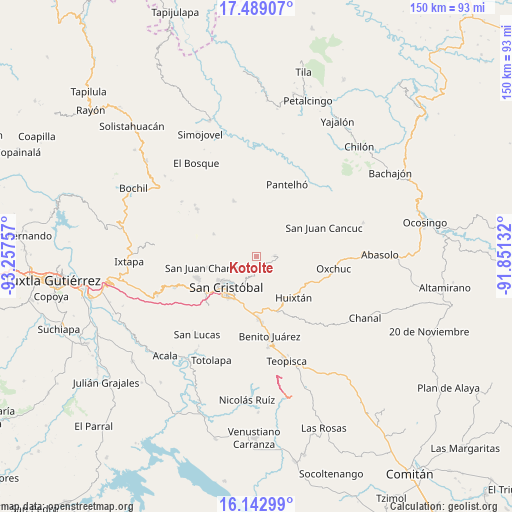
Kotolte GPS coordinates[2]
16° 49' 1.992" North, 92° 33' 15.984" West
| Map corner | latitude | longitude |
|---|---|---|
| Upper-left | 17.48907°, | -93.25757° |
| Center: | 16.81722°, | -92.55444° |
| Lower-right: | 16.14299°, | -91.85132° |
| Map W x H: | 149.7×149.7 km | = 93×93mi |
| max Lat: | 32.7° ⇑91.5% North |
| Kotolte: | 16.81722° |
| min Lat: | ⇓8.5% South 14.53588° |
| min Long | Kotolte | max Long |
| -117.105° | -92.55444° | -86.73105° |
| W 91.4%⇐ | ⇒8.6% E |
Elevation
Elevation of Kotolte is 2425 m = 7956 ft, and this is 1171.3 m = 3843 ft above average elevation for this country.
| Max E: |
3497 m = 11473 ft | 9.5% |
| Kotolte | 2425 m 7956 ft | |
| Avg. | 1253.7 m = 4113 ft | |
Min E: |
-1 m = -3 ft | 90.5% |
See also: Mexico elevation on elevation.city.
Geographical zone
Kotolte is located in North Torrid zone (between Equator and Tropic of Cancer). Distance of this Northern Tropic circle is 736 km =457.3 mi to North.| Distance of | km | miles | from Kotolte |
|---|---|---|---|
| North Pole | 8137.2 | 5056.2 | to North |
| Arctic Circle | 5531.3 | 3437 | to North |
| Tropic Cancer | 736 | 457.3 | to North |
| Equator | 1869.9 | 1161.9 | to South |


Nearby cities:
15 places around Kotolte: (largest is in red/bold)
• Cañada Grande
3.4 km =2.1 mi,  88°
88°
• Chilimjoveltic
4.2 km =2.6 mi,  219°
219°
• El Crucero
2.3 km =1.4 mi,  214°
214°
• El Pozo
4.3 km =2.7 mi,  334°
334°
• Las Ollas
4 km =2.5 mi,  177°
177°
• Muquén
6 km =3.7 mi,  258°
258°
• Oxinam
5.1 km =3.2 mi,  6°
6°
• Pajaltón
3.2 km =2 mi,  52°
52°
• Pajaltón Alto
2.3 km =1.4 mi,  305°
305°
• Pajaltón Bajo
2.4 km =1.5 mi, 6°
• Romerillo
5.9 km =3.7 mi,  193°
193°
• Sactzu
6.2 km =3.9 mi,  247°
247°
• Tenejapa
5.1 km =3.2 mi, 88°
• Titaltetic
6.2 km =3.9 mi,  358°
358°
• Tzontehuitz
3.2 km =2 mi,  303°
303°
Sources, notices
• [Note1] Compared only with cities in Mexico existing in our database
• [Src1] Map data: © OpenStreetMap contributors (CC-BY-SA)
• [Src2] Other city data from geonames.org with taken over terms of usage.
• [Src3] Geographical zone / Annual Mean Temperature by Robert A. Rohde @ Wikipedia
