Tenexate geodata
Tenexate (Puebla) is a populated place; located in Mexico in America/Mexico_City (GMT-6) time zone. With population of 728 people, there are 11990 cities with bigger population in this country. Compared to other cities in Mexico, 60.1% of cities are located further ↓South; 71% of cities are located further ←West and 73.2% of cities have higher elevation than Tenexate. Note1


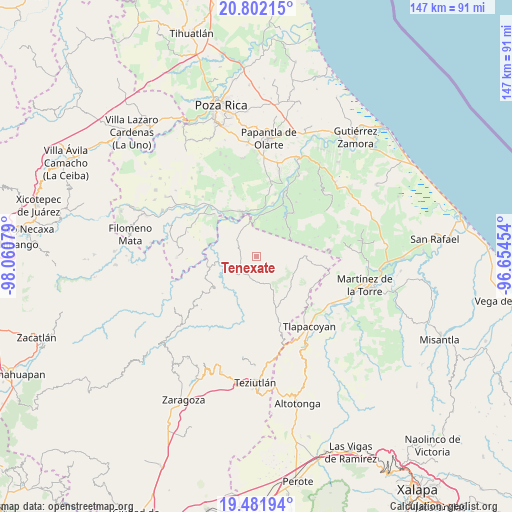
Tenexate GPS coordinates[2]
20° 8' 36.384" North, 97° 21' 27.576" West
| Map corner | latitude | longitude |
|---|---|---|
| Upper-left | 20.80215°, | -98.06079° |
| Center: | 20.14344°, | -97.35766° |
| Lower-right: | 19.48194°, | -96.65454° |
| Map W x H: | 146.8×146.8 km | = 91.2×91.2mi |
| max Lat: | 32.7° ⇑39.9% North |
| Tenexate: | 20.14344° |
| min Lat: | ⇓60.1% South 14.53588° |
| min Long | Tenexate | max Long |
| -117.105° | -97.35766° | -86.73105° |
| W 71%⇐ | ⇒29% E |
Elevation
Elevation of Tenexate is 281 m = 922 ft, and this is 972.7 m = 3191 ft below average elevation for this country.
| Max E: |
3497 m = 11473 ft | 73.2% |
| Avg. | 1253.7 m = 4113 ft | |
| Tenexate | 281 m = 922 ft | |
Min E: |
-1 m = -3 ft | 26.8% |
See also: Mexico elevation on elevation.city.
Geographical zone
Tenexate is located in North Torrid zone (between Equator and Tropic of Cancer). Distance of this Northern Tropic circle is 366.2 km =227.5 mi to North.| Distance of | km | miles | from Tenexate |
|---|---|---|---|
| North Pole | 7767.3 | 4826.4 | to North |
| Arctic Circle | 5161.4 | 3207.1 | to North |
| Tropic Cancer | 366.2 | 227.5 | to North |
| Equator | 2239.7 | 1391.7 | to South |


Nearby cities:
15 places around Tenexate: (largest is in red/bold)
• Ayotoxco de Guerrero
7.6 km =4.7 mi,  225°
225°
• Belisario Domínguez
9.6 km =6 mi,  36°
36°
• Buena Vista
10.2 km =6.3 mi,  260°
260°
• Cuauhtapanaloyan
13 km =8.1 mi, 233°
• El Cedral
12.4 km =7.7 mi,  10°
10°
• Gachupinate
5.7 km =3.5 mi,  236°
236°
• Guadalupe Victoria
13.3 km =8.3 mi,  353°
353°
• Insurgente Socialista
11.1 km =6.9 mi,  63°
63°
• Joloapan
13.5 km =8.4 mi, 38°
• La Lima
5.6 km =3.5 mi,  292°
292°
• Pajasco Limonar
13.3 km =8.3 mi,  1°
1°
• San Antonio Metzonapa
10.4 km =6.5 mi,  192°
192°
• San Antonio Rayón
13.5 km =8.4 mi,  254°
254°
• Tecpantzingo
12.3 km =7.6 mi, 247°
• Tenampulco
5.8 km =3.6 mi,  301°
301°
Sources, notices
• [Note1] Compared only with cities in Mexico existing in our database
• [Src1] Map data: © OpenStreetMap contributors (CC-BY-SA)
• [Src2] Other city data from geonames.org with taken over terms of usage.
• [Src3] Geographical zone / Annual Mean Temperature by Robert A. Rohde @ Wikipedia
