Sudzal geodata
Sudzal (Yucatán) is a populated place; located in Mexico in America/Merida (GMT-6) time zone. With population of 1,261 people, there are 6866 cities with bigger population in this country. Compared to other cities in Mexico, 74.4% of cities are located further ↓South; 98.8% of cities are located further ←West and 92.1% of cities have higher elevation than Sudzal. Note1


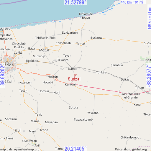
Sudzal GPS coordinates[2]
20° 52' 20.856" North, 88° 59' 20.004" West
| Map corner | latitude | longitude |
|---|---|---|
| Upper-left | 21.52799°, | -89.69202° |
| Center: | 20.87246°, | -88.98889° |
| Lower-right: | 20.21405°, | -88.28577° |
| Map W x H: | 146.1×146.1 km | = 90.8×90.8mi |
| max Lat: | 32.7° ⇑25.6% North |
| Sudzal: | 20.87246° |
| min Lat: | ⇓74.4% South 14.53588° |
| min Long | Sudzal | max Long |
| -117.105° | -88.98889° | -86.73105° |
| W 98.8%⇐ | ⇒1.2% E |
Elevation
Elevation of Sudzal is 19 m = 62 ft, and this is 1234.7 m = 4051 ft below average elevation for this country.
| Max E: |
3497 m = 11473 ft | 92.1% |
| Avg. | 1253.7 m = 4113 ft | |
| Sudzal | 19 m = 62 ft | |
Min E: |
-1 m = -3 ft | 7.9% |
See also: Mexico elevation on elevation.city.
Geographical zone
Sudzal is located in North Torrid zone (between Equator and Tropic of Cancer). Distance of this Northern Tropic circle is 285.1 km =177.2 mi to North.| Distance of | km | miles | from Sudzal |
|---|---|---|---|
| North Pole | 7686.3 | 4776 | to North |
| Arctic Circle | 5080.4 | 3156.8 | to North |
| Tropic Cancer | 285.1 | 177.2 | to North |
| Equator | 2320.8 | 1442.1 | to South |


Nearby cities:
15 places around Sudzal: (largest is in red/bold)
• Citilcum
16 km =9.9 mi,  303°
303°
• Cuauhtémoc
2 km =1.2 mi,  326°
326°
• Holca
14.3 km =8.9 mi,  154°
154°
• Izamal
7.6 km =4.7 mi,  336°
336°
• Kantunil
9.7 km =6 mi,  209°
209°
• Kimbila
15.7 km =9.8 mi, 295°
• Sahcaba
21.9 km =13.6 mi,  245°
245°
• San José Oriente
11.8 km =7.3 mi,  263°
263°
• Sitilpech
8.3 km =5.2 mi,  23°
23°
• Tekal de Venegas
16.4 km =10.2 mi, 15°
• Tekanto
19.6 km =12.2 mi,  321°
321°
• Tepakan
20.3 km =12.6 mi,  345°
345°
• Teya
21.7 km =13.5 mi, 336°
• Xanabá
4.8 km =3 mi, 212°
• Xocchel
20.7 km =12.9 mi, 257°
Sources, notices
• [Note1] Compared only with cities in Mexico existing in our database
• [Src1] Map data: © OpenStreetMap contributors (CC-BY-SA)
• [Src2] Other city data from geonames.org with taken over terms of usage.
• [Src3] Geographical zone / Annual Mean Temperature by Robert A. Rohde @ Wikipedia
