Cuauhtémoc geodata
Cuauhtémoc (Yucatán) is a populated place; located in Mexico in America/Merida (GMT-6) time zone. With population of 600 people, there are 14337 cities with bigger population in this country. Compared to other cities in Mexico, 74.6% of cities are located further ↓South; 98.8% of cities are located further ←West and 91.6% of cities have higher elevation than Cuauhtémoc. Note1


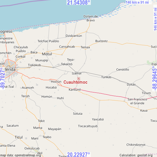
Cuauhtémoc GPS coordinates[2]
20° 53' 15.396" North, 88° 59' 58.452" West
| Map corner | latitude | longitude |
|---|---|---|
| Upper-left | 21.54308°, | -89.7027° |
| Center: | 20.88761°, | -88.99957° |
| Lower-right: | 20.22927°, | -88.29645° |
| Map W x H: | 146.1×146.1 km | = 90.8×90.8mi |
| max Lat: | 32.7° ⇑25.4% North |
| Cuauhtémoc: | 20.88761° |
| min Lat: | ⇓74.6% South 14.53588° |
| min Long | Cuauhtémoc | max Long |
| -117.105° | -88.99957° | -86.73105° |
| W 98.8%⇐ | ⇒1.2% E |
Elevation
Elevation of Cuauhtémoc is 20 m = 66 ft, and this is 1233.7 m = 4048 ft below average elevation for this country.
| Max E: |
3497 m = 11473 ft | 91.6% |
| Avg. | 1253.7 m = 4113 ft | |
| Cuauhtémoc | 20 m = 66 ft | |
Min E: |
-1 m = -3 ft | 8.4% |
See also: Mexico elevation on elevation.city.
Geographical zone
Cuauhtémoc is located in North Torrid zone (between Equator and Tropic of Cancer). Distance of this Northern Tropic circle is 283.4 km =176.1 mi to North.| Distance of | km | miles | from Cuauhtémoc |
|---|---|---|---|
| North Pole | 7684.6 | 4775 | to North |
| Arctic Circle | 5078.7 | 3155.8 | to North |
| Tropic Cancer | 283.4 | 176.1 | to North |
| Equator | 2322.5 | 1443.1 | to South |


Nearby cities:
15 places around Cuauhtémoc: (largest is in red/bold)
• Citilcum
14.2 km =8.8 mi,  299°
299°
• Hoctun
21.1 km =13.1 mi,  263°
263°
• Holca
16.3 km =10.1 mi,  153°
153°
• Izamal
5.6 km =3.5 mi,  340°
340°
• Kantunil
10.8 km =6.7 mi,  200°
200°
• Kimbila
14 km =8.7 mi,  291°
291°
• San José Oriente
11.1 km =6.9 mi,  253°
253°
• Sitilpech
7.4 km =4.6 mi,  37°
37°
• Sudzal
2 km =1.2 mi, 146°
• Tekal de Venegas
15.2 km =9.4 mi,  21°
21°
• Tekanto
17.6 km =10.9 mi,  320°
320°
• Tepakan
18.4 km =11.4 mi,  347°
347°
• Teya
19.7 km =12.2 mi, 337°
• Xanabá
5.9 km =3.7 mi,  194°
194°
• Xocchel
20 km =12.4 mi, 252°
Sources, notices
• [Note1] Compared only with cities in Mexico existing in our database
• [Src1] Map data: © OpenStreetMap contributors (CC-BY-SA)
• [Src2] Other city data from geonames.org with taken over terms of usage.
• [Src3] Geographical zone / Annual Mean Temperature by Robert A. Rohde @ Wikipedia
