San Juan Cotzocón geodata
San Juan Cotzocón (Oaxaca) is a populated place; located in Mexico in America/Mexico_City (GMT-6) time zone. With population of 3,700 people, there are 2482 cities with bigger population in this country. Compared to other cities in Mexico, 86.9% of cities are located further ↑North; 82.7% of cities are located further ←West and 54% of cities have higher elevation than San Juan Cotzocón. Note1


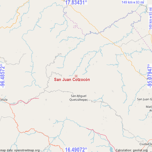
San Juan Cotzocón GPS coordinates[2]
17° 9' 49.428" North, 95° 46' 57.324" West
| Map corner | latitude | longitude |
|---|---|---|
| Upper-left | 17.83431°, | -96.48572° |
| Center: | 17.16373°, | -95.78259° |
| Lower-right: | 16.49072°, | -95.07947° |
| Map W x H: | 149.4×149.4 km | = 92.8×92.8mi |
| max Lat: | 32.7° ⇑86.9% North |
| San Juan Cotzocón: | 17.16373° |
| min Lat: | ⇓13.1% South 14.53588° |
| min Long | San Juan Cotzoc | max Long |
| -117.105° | -95.78259° | -86.73105° |
| W 82.7%⇐ | ⇒17.3% E |
Elevation
Elevation of San Juan Cotzocón is 1240 m = 4068 ft, and this is 13.7 m = 45 ft below average elevation for this country.
| Max E: |
3497 m = 11473 ft | 54% |
| Avg. | 1253.7 m = 4113 ft | |
| San Juan Cotzocón | 1240 m = 4068 ft | |
Min E: |
-1 m = -3 ft | 46% |
See also: Mexico elevation on elevation.city.
Geographical zone
San Juan Cotzocón is located in North Torrid zone (between Equator and Tropic of Cancer). Distance of this Northern Tropic circle is 697.5 km =433.4 mi to North.| Distance of | km | miles | from San Juan Cotzocón |
|---|---|---|---|
| North Pole | 8098.6 | 5032.2 | to North |
| Arctic Circle | 5492.7 | 3413 | to North |
| Tropic Cancer | 697.5 | 433.4 | to North |
| Equator | 1908.4 | 1185.8 | to South |


Nearby cities:
15 places around San Juan Cotzocón: (largest is in red/bold)
• Cacalotepec
23.3 km =14.5 mi,  232°
232°
• Cerro Moneda
22.1 km =13.7 mi,  220°
220°
• Estancia de Morelos
16.9 km =10.5 mi, 222°
• La Candelaria
17.1 km =10.6 mi,  290°
290°
• San Francisco Jayacaxtepec
21.4 km =13.3 mi, 287°
• San Juan Metaltepec
13.8 km =8.6 mi,  275°
275°
• San Miguel Quetzaltepec
21.2 km =13.2 mi,  173°
173°
• San Pedro Ayacaxtepec
11.5 km =7.1 mi,  244°
244°
• San Pedro Chimaltepec
22.8 km =14.2 mi,  145°
145°
• Santa Cruz Ocotal
20.8 km =12.9 mi,  192°
192°
• Santa María Alotepec
11 km =6.8 mi, 223°
• Santa María Puxmetacán
20.5 km =12.7 mi,  55°
55°
• Santiago Altitlán
18.6 km =11.6 mi,  249°
249°
• Santiago Yaveo
21 km =13 mi,  24°
24°
• Santiago Zacatepec
14 km =8.7 mi,  268°
268°
Sources, notices
• [Note1] Compared only with cities in Mexico existing in our database
• [Src1] Map data: © OpenStreetMap contributors (CC-BY-SA)
• [Src2] Other city data from geonames.org with taken over terms of usage.
• [Src3] Geographical zone / Annual Mean Temperature by Robert A. Rohde @ Wikipedia
