Santiago Chazumba geodata
Santiago Chazumba (Oaxaca) is a seat of a second-order administrative division; located in Mexico in America/Mexico_City (GMT-6) time zone. With population of 1,918 people, there are 4534 cities with bigger population in this country. Compared to other cities in Mexico, 76.3% of cities are located further ↑North; 67.5% of cities are located further ←West and 59.6% of cities have lower elevation than Santiago Chazumba. Note1


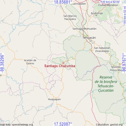
Santiago Chazumba GPS coordinates[2]
18° 11' 24.432" North, 97° 40' 47.388" West
| Map corner | latitude | longitude |
|---|---|---|
| Upper-left | 18.85681°, | -98.38296° |
| Center: | 18.19012°, | -97.67983° |
| Lower-right: | 17.52087°, | -96.97671° |
| Map W x H: | 148.5×148.5 km | = 92.3×92.3mi |
| max Lat: | 32.7° ⇑76.3% North |
| Santiago Chazumba: | 18.19012° |
| min Lat: | ⇓23.7% South 14.53588° |
| min Long | Santiago Chazum | max Long |
| -117.105° | -97.67983° | -86.73105° |
| W 67.5%⇐ | ⇒32.5% E |
Elevation
Elevation of Santiago Chazumba is 1720 m = 5643 ft, and this is 466.3 m = 1530 ft above average elevation for this country.
| Max E: |
3497 m = 11473 ft | 40.4% |
| Santiago Chazumba | 1720 m 5643 ft | |
| Avg. | 1253.7 m = 4113 ft | |
Min E: |
-1 m = -3 ft | 59.6% |
See also: Mexico elevation on elevation.city.
Geographical zone
Santiago Chazumba is located in North Torrid zone (between Equator and Tropic of Cancer). Distance of this Northern Tropic circle is 583.4 km =362.5 mi to North.| Distance of | km | miles | from Santiago Chazumba |
|---|---|---|---|
| North Pole | 7984.5 | 4961.3 | to North |
| Arctic Circle | 5378.6 | 3342.1 | to North |
| Tropic Cancer | 583.4 | 362.5 | to North |
| Equator | 2022.6 | 1256.8 | to South |


Nearby cities:
15 places around Santiago Chazumba: (largest is in red/bold)
• Atexcal
24 km =14.9 mi,  346°
346°
• Cosoltepec
12.9 km =8 mi,  245°
245°
• Petlalcingo
27.7 km =17.2 mi,  244°
244°
• San Jerónimo Xayacatlán
24.8 km =15.4 mi,  277°
277°
• San Lucas
19.4 km =12.1 mi,  18°
18°
• San Mateo Zoyamazalco
28.6 km =17.8 mi,  333°
333°
• San Miguel Ixitlán
23.3 km =14.5 mi,  205°
205°
• San Pedro y San Pablo Tequistepec
14.9 km =9.3 mi,  195°
195°
• San Vicente Coyotepec
28.6 km =17.8 mi, 326°
• Santiago Miltepec
22.9 km =14.2 mi,  182°
182°
• Santo Domingo Tonahuíxtla
22.2 km =13.8 mi,  273°
273°
• Teloxtoc
23.5 km =14.6 mi,  26°
26°
• Tepejillo
22.9 km =14.2 mi,  227°
227°
• Totoltepec de Guerrero
18.9 km =11.7 mi, 282°
• Zapotitlán
26.7 km =16.6 mi,  54°
54°
Sources, notices
• [Note1] Compared only with cities in Mexico existing in our database
• [Src1] Map data: © OpenStreetMap contributors (CC-BY-SA)
• [Src2] Other city data from geonames.org with taken over terms of usage.
• [Src3] Geographical zone / Annual Mean Temperature by Robert A. Rohde @ Wikipedia
