San Vicente Coyotepec geodata
San Vicente Coyotepec (Puebla) is a populated place; located in Mexico in America/Mexico_City (GMT-6) time zone. With population of 1,296 people, there are 6684 cities with bigger population in this country. Compared to other cities in Mexico, 73.7% of cities are located further ↑North; 65.7% of cities are located further ←West and 68.4% of cities have lower elevation than San Vicente Coyotepec. Note1
Current local time in San Vicente Coyotepec:
08:44 AM, WednesdayDifference from your time zone: hours


San Vicente Coyotepec GPS coordinates[2]
18° 24' 15.804" North, 97° 49' 45.264" West
| Map corner | latitude | longitude |
|---|---|---|
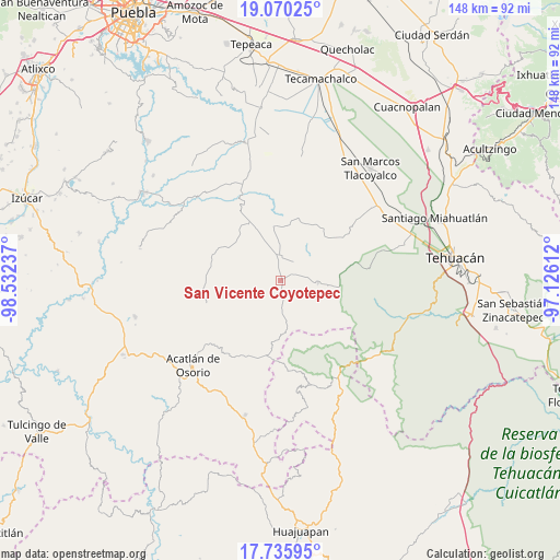
| Upper-left | 19.07025°, | -98.53237° |
| Center: | 18.40439°, | -97.82924° |
| Lower-right: | 17.73595°, | -97.12612° |
| Map W x H: | 148.4×148.4 km | = 92.2×92.2mi |
| max Lat: | 32.7° ⇑73.7% North |
| San Vicente Coyotepec: | 18.40439° |
| min Lat: | ⇓26.3% South 14.53588° |
| min Long | San Vicente Coy | max Long |
| -117.105° | -97.82924° | -86.73105° |
| W 65.7%⇐ | ⇒34.3% E |
Elevation
Elevation of San Vicente Coyotepec is 1897 m = 6224 ft, and this is 643.3 m = 2111 ft above average elevation for this country.
| Max E: |
3497 m = 11473 ft | 31.6% |
| San Vicente Coyotepec | 1897 m 6224 ft | |
| Avg. | 1253.7 m = 4113 ft | |
Min E: |
-1 m = -3 ft | 68.4% |
See also: Mexico elevation on elevation.city.
Geographical zone
San Vicente Coyotepec is located in North Torrid zone (between Equator and Tropic of Cancer). Distance of this Northern Tropic circle is 559.5 km =347.7 mi to North.| Distance of | km | miles | from San Vicente Coyotepec |
|---|---|---|---|
| North Pole | 7960.7 | 4946.5 | to North |
| Arctic Circle | 5354.8 | 3327.3 | to North |
| Tropic Cancer | 559.5 | 347.7 | to North |
| Equator | 2046.4 | 1271.6 | to South |


Nearby cities:
15 places around San Vicente Coyotepec: (largest is in red/bold)
• Agua Santa Ana
18.2 km =11.3 mi,  312°
312°
• Almolonga
16.3 km =10.1 mi,  299°
299°
• Atexcal
10 km =6.2 mi,  92°
92°
• Chapultepec (Santo Domingo)
19.3 km =12 mi, 298°
• El Progreso
17.6 km =10.9 mi,  350°
350°
• Guadalupe Victoria
14.8 km =9.2 mi, 353°
• Huajoyuca
16.6 km =10.3 mi,  316°
316°
• Huejonapan
12.1 km =7.5 mi, 306°
• Juan N. Méndez
16.6 km =10.3 mi,  21°
21°
• Magdalena Alquizapán
11.3 km =7 mi,  40°
40°
• Mariscala
15.7 km =9.8 mi, 323°
• San Felipe Otlaltepec
8.3 km =5.2 mi,  267°
267°
• San Juan Ixcaquixtla
6.3 km =3.9 mi,  358°
358°
• San Mateo Zoyamazalco
3.6 km =2.2 mi,  59°
59°
• Tula
17.1 km =10.6 mi,  330°
330°
Sources, notices
• [Note1] Compared only with cities in Mexico existing in our database
• [Src1] Map data: © OpenStreetMap contributors (CC-BY-SA)
• [Src2] Other city data from geonames.org with taken over terms of usage.
• [Src3] Geographical zone / Annual Mean Temperature by Robert A. Rohde @ Wikipedia
