San Lucas geodata
San Lucas (Puebla) is a populated place; located in Mexico in America/Mexico_City (GMT-6) time zone. With population of 735 people, there are 11887 cities with bigger population in this country. Compared to other cities in Mexico, 74.3% of cities are located further ↑North; 68.2% of cities are located further ←West and 70.5% of cities have lower elevation than San Lucas. Note1


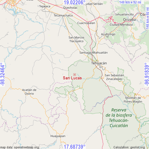
San Lucas GPS coordinates[2]
18° 21' 21.636" North, 97° 37' 17.436" West
| Map corner | latitude | longitude |
|---|---|---|
| Upper-left | 19.02206°, | -98.32464° |
| Center: | 18.35601°, | -97.62151° |
| Lower-right: | 17.68739°, | -96.91839° |
| Map W x H: | 148.4×148.4 km | = 92.2×92.2mi |
| max Lat: | 32.7° ⇑74.3% North |
| San Lucas: | 18.35601° |
| min Lat: | ⇓25.7% South 14.53588° |
| min Long | San Lucas | max Long |
| -117.105° | -97.62151° | -86.73105° |
| W 68.2%⇐ | ⇒31.8% E |
Elevation
Elevation of San Lucas is 1935 m = 6348 ft, and this is 681.3 m = 2235 ft above average elevation for this country.
| Max E: |
3497 m = 11473 ft | 29.5% |
| San Lucas | 1935 m 6348 ft | |
| Avg. | 1253.7 m = 4113 ft | |
Min E: |
-1 m = -3 ft | 70.5% |
See also: Mexico elevation on elevation.city.
Geographical zone
San Lucas is located in North Torrid zone (between Equator and Tropic of Cancer). Distance of this Northern Tropic circle is 564.9 km =351 mi to North.| Distance of | km | miles | from San Lucas |
|---|---|---|---|
| North Pole | 7966.1 | 4949.9 | to North |
| Arctic Circle | 5360.2 | 3330.7 | to North |
| Tropic Cancer | 564.9 | 351 | to North |
| Equator | 2041 | 1268.2 | to South |


Nearby cities:
15 places around San Lucas: (largest is in red/bold)
• Atexcal
12.9 km =8 mi,  292°
292°
• Francisco Ignacio Madero
22.6 km =14 mi,  47°
47°
• Magdalena Alquizapán
20.2 km =12.6 mi,  313°
313°
• San Andrés Cacaloapan
25.6 km =15.9 mi,  8°
8°
• San José Monte Chiquito
24.8 km =15.4 mi, 51°
• San Juan Atzingo
25.6 km =15.9 mi,  104°
104°
• San Juan Ixcaquixtla
25 km =15.5 mi,  297°
297°
• San Mateo Zoyamazalco
20.1 km =12.5 mi, 291°
• San Vicente Coyotepec
22.6 km =14 mi,  283°
283°
• Santiago Chazumba
19.4 km =12.1 mi,  198°
198°
• Teloxtoc
5.1 km =3.2 mi,  59°
59°
• Teontepec
18 km =11.2 mi,  32°
32°
• Tepanco
23.2 km =14.4 mi,  15°
15°
• Texcala
19.2 km =11.9 mi,  76°
76°
• Zapotitlán
15.8 km =9.8 mi, 100°
Sources, notices
• [Note1] Compared only with cities in Mexico existing in our database
• [Src1] Map data: © OpenStreetMap contributors (CC-BY-SA)
• [Src2] Other city data from geonames.org with taken over terms of usage.
• [Src3] Geographical zone / Annual Mean Temperature by Robert A. Rohde @ Wikipedia
