San Sebastián Coatlán geodata
San Sebastián Coatlán (Oaxaca) is a seat of a second-order administrative division; located in Mexico in America/Mexico_City (GMT-6) time zone. With population of 1,258 people, there are 6880 cities with bigger population in this country. Compared to other cities in Mexico, 96.3% of cities are located further ↑North; 76.9% of cities are located further ←West and 72.7% of cities have lower elevation than San Sebastián Coatlán. Note1


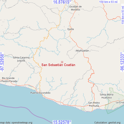
San Sebastián Coatlán GPS coordinates[2]
16° 12' 7.632" North, 96° 49' 35.22" West
| Map corner | latitude | longitude |
|---|---|---|
| Upper-left | 16.87615°, | -97.52958° |
| Center: | 16.20212°, | -96.82645° |
| Lower-right: | 15.52578°, | -96.12333° |
| Map W x H: | 150.1×150.1 km | = 93.3×93.3mi |
| max Lat: | 32.7° ⇑96.3% North |
| San Sebastián Coatlán: | 16.20212° |
| min Lat: | ⇓3.7% South 14.53588° |
| min Long | San Sebastián | max Long |
| -117.105° | -96.82645° | -86.73105° |
| W 76.9%⇐ | ⇒23.1% E |
Elevation
Elevation of San Sebastián Coatlán is 1983 m = 6506 ft, and this is 729.3 m = 2393 ft above average elevation for this country.
| Max E: |
3497 m = 11473 ft | 27.3% |
| San Sebastián Coatlán | 1983 m 6506 ft | |
| Avg. | 1253.7 m = 4113 ft | |
Min E: |
-1 m = -3 ft | 72.7% |
See also: Mexico elevation on elevation.city.
Geographical zone
San Sebastián Coatlán is located in North Torrid zone (between Equator and Tropic of Cancer). Distance of this Northern Tropic circle is 804.4 km =499.8 mi to North.| Distance of | km | miles | from San Sebastián Coatlán |
|---|---|---|---|
| North Pole | 8205.6 | 5098.7 | to North |
| Arctic Circle | 5599.7 | 3479.5 | to North |
| Tropic Cancer | 804.4 | 499.8 | to North |
| Equator | 1801.5 | 1119.4 | to South |


Nearby cities:
15 places around San Sebastián Coatlán: (largest is in red/bold)
• San Baltazar Loxicha
14.6 km =9.1 mi,  163°
163°
• San Francisco Coatlán
7.3 km =4.5 mi,  107°
107°
• San Jerónimo Coatlán
5.8 km =3.6 mi,  305°
305°
• San José Llano Cieneguilla
21.1 km =13.1 mi,  204°
204°
• San Miguel Coatlán
14.1 km =8.8 mi,  92°
92°
• San Miguel Yogovana
22.5 km =14 mi,  67°
67°
• San Pablo Coatlán
5.2 km =3.2 mi,  61°
61°
• San Pedro Coatlán
10.5 km =6.5 mi, 56°
• San Vicente Coatlán
20.8 km =12.9 mi,  354°
354°
• Santa Ana
19.4 km =12.1 mi,  37°
37°
• Santa Catarina Coatlán
12.1 km =7.5 mi,  27°
27°
• Santa Catarina Loxicha
16.7 km =10.4 mi,  152°
152°
• Santa Cruz Xitla
21.1 km =13.1 mi,  50°
50°
• Santa Lucía
22.7 km =14.1 mi, 93°
• Soledad Piedra Larga
22.6 km =14 mi,  250°
250°
Sources, notices
• [Note1] Compared only with cities in Mexico existing in our database
• [Src1] Map data: © OpenStreetMap contributors (CC-BY-SA)
• [Src2] Other city data from geonames.org with taken over terms of usage.
• [Src3] Geographical zone / Annual Mean Temperature by Robert A. Rohde @ Wikipedia
